Paperis Articles
Trade Routes — A Transit Map Where Goods Were Handed On at Every Transfer
The Silk Roads were a branching network, a relay of short stretches in which goods passed from trader to trader. Monsoon winds moved shipping on the Indian Ocean, camel caravans crossed the Sahara, and beliefs, disease and enslaved people traveled with the goods. After 1492, disease and violence that crossed the Atlantic with the crops devastated Indigenous Americans, and Europeans forcibly transported some twelve million Africans.
Your field's papers, as audio
Pick your fields and journals — Paperis summarizes the key papers and turns them into audio. Listen on your commute.
Start Paperis free →Trade Routes — A Transit Map Where Goods Were Handed On at Every Transfer
The Shopping List from 752
In 752, the Silla envoy Kim Tae-ryeom crossed the sea to Japan. From that time, there is a list in which Japanese royalty and nobles wrote down the foreign goods brought in by the Silla delegation that they wanted to buy. The list includes spices, medicinal herbs, and dyes for coloring cloth. Their places of origin were Southeast Asia, India, and lands even further west (DOI: 10.21490/jskh.2022.11.89.265).
A single list contains several seas and multiple countries. How many hands those goods passed through to reach a Japanese noble is not written on the list. This article follows those blanks.
Trade is the act of buying, selling, or exchanging goods between people and societies. This article covers trade across various regions of the world, crossing in turn the overland routes spanning Asia, the sea lanes of the Indian Ocean and the Yellow Sea, the Sahara Desert, and the Atlantic Ocean. The sea routes of Silla and Goryeo are also placed in the same spot, as there is research on them in Korean academia.
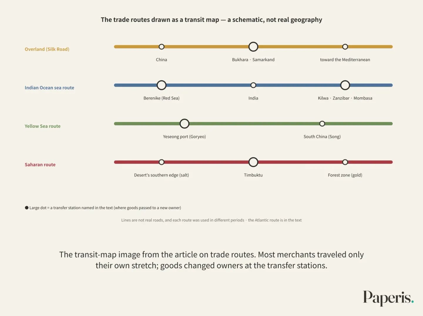
As a guide, we bring along a subway route map. On the route map, there are multiple lines, and transfer stations where lines meet. Most passengers do not ride a single line all the way to the end, but go a few stops and transfer. On the roads of ancient trade, what transferred and went to distant places was mostly goods, and the transfer stations were oasis cities and ports.
The Silk Road Is a Single Transit Map
The Silk Road is the collective name for the multiple overland and maritime routes that connected China and the Mediterranean. When you look at it on a transit map, this name does not refer to a single line, but to an entire transit map (OpenStax World History Volume 1 12.2). A network is a fabric where multiple paths and the hubs where those paths meet are linked like a net.
On this transit map, it was rare for a merchant to travel a long distance from start to finish. Everyone only traveled their own stretch, and goods passed to new owners whenever the section changed (OpenStax World History Volume 1 12.2). Controlling a transfer station itself was the business. The Sogdians, who lived in the lands of modern-day Uzbekistan and Tajikistan, controlled oasis cities like Bukhara and Samarkand from the late fourth century onward and led trade in that region for hundreds of years. Sogdian merchants also played a role in spreading Buddhism outside South Asia as early as the fourth century (OpenStax World History Volume 1 12.3).
The routes are older than the name. In the second millennium BCE, starch-rich crops are already found in various parts of Eurasia far from where they originally grew (DOI: 10.1080/00438243.2011.624764). Looking at China, wheat, barley, and dates had already arrived before the overland Silk Road routes were established, while crops such as grapes, walnuts, spinach, and cucumbers arrived along those paths through trade and migration. Some crops still have conflicting evidence and have not yet been sorted out (DOI: 10.1186/s12870-022-04022-9).
The Silk Road was a network where goods passed to new owners at each section, and parts of that route were used long before they got a name.
The Sea Whose Timetable Was Set by the Wind
On the Red Sea coast of Egypt, about 500 miles (roughly 800 km) south of today's Suez Canal, lies the ancient port site of Berenike. An empire is a political entity in which a single center rules over several different peoples and a vast territory, usually bound together by military force. At the height of the Roman Empire surrounding the Mediterranean, the sea route from Berenike across the Indian Ocean to Asia was just as important as the land routes. This is how the archaeologist who directly excavated the port sums it up in a book (DOI: 10.1525/9780520948389).
The sea routes had a timetable, and that timetable was set by the wind. Monsoons are winds that change direction depending on the season. In the Indian Ocean, they pushed ships toward India in the summer and toward Africa in the winter (OpenStax World History Volume 1 12.2). Merchants who reached India in the summer could not return until the winter winds blew. While waiting, they stayed long in the local society and culture, allowing ideas and beliefs to spread further (OpenStax World History Volume 1 12.1).
By around the 12th century, the East African coast had become one of the centers of Indian Ocean trade. Cities like Mombasa, Zanzibar, and Kilwa sat along the path of the monsoons, and Kilwa controlled the gold trade to become the most important of these coastal cities. Islam also spread among merchants along this sea route. People were sold like goods along the same sea routes. People bought from the interior of Africa were loaded onto ships and sent to what is now southern Iraq, where those working in the marshes staged a major uprising in 868. The uprising was suppressed in 883 (OpenStax World History Volume 1 12.2).
There were also times when cargo shifted to a different route because one route was blocked. As the Persian and Byzantine Empires fought, trade on the overland Silk Road decreased in the 5th and 6th centuries, while trade along sea routes through the Persian Gulf increased, according to one study (DOI: 10.1353/jwh.2003.0005).
The paths of the sea routes followed a timetable set by the monsoons, and their ships carried goods, beliefs, and people sold as slaves together.
The Sea Route Across the Yellow Sea: Silla and Goryeo
Glass-like artifacts from Hwangnamdaegeom in Gyeongju show that cultures from China's western border and beyond influenced Silla art (KCI ART001855484). The Korean Peninsula was also connected to one branch of this roadmap. The 752 list we saw earlier tells the same story. Goods originating in Southeast Asia and India reached Japan via the hands of Silla delegations (DOI: 10.21490/jskh.2022.11.89.265).
There is research suggesting that the sea route between Goryeo and the Song dynasty also moved along the winds. Ships of Song merchants mostly reached Yesonghang, the official port near Goryeo's capital Gaegyeong, during the 7th and 8th lunar months, and next in the 5th and 6th lunar months. This study views the arrivals around May as riding the spring southerly wind (southwesterly wind) as commonly said, and sees the 7th and 8th months as a time when southerly and northeasterly winds intersect, leading merchants to set sail by observing the wind direction. Goryeo envoys mostly departed for southern China in the 2nd and 3rd and the 7th and 8th lunar months, and this study suggests they rode the northeasterly winds blowing at those times. This is a conclusion different from the existing view that Song merchants returned by riding the winter northerly winds. It also suggests that it was frequent for Song merchants to travel back and forth twice a year. However, the author adds that further verification through meteorological analysis is needed (KCI ART001923072).
On this sea route, the very act of transporting other people's goods was business. Entrepot trade is a trade where one makes a profit by receiving goods from one side and passing them to the other, without directly making or using the goods. Song merchants who owned ships brokered and transported goods for neighboring countries. There were also those who stayed in Goryeo for a long time and married Goryeo women (KCI ART001323829).
The goods that went back and forth were not just luxury items. Goryeo sold celadon and Goryeo-po (Goryeo hemp cloth) heavily used in daily life to China, and bought raw silk to weave into silk and sell back. It was also one of the main suppliers providing silver to the Song dynasty. Based on these exports, one study estimates that a commodity economy based on maritime trade had developed in Goryeo as well (DOI: 10.18347/hufshis.2016.60.151).
It was not only the wind that opened and closed routes. When the Ming dynasty banned maritime trade in the late Goryeo period, Yesonghang, which had been the center of sea trade with China, gradually lost its function (KCI ART001888055).
The Desert Crossed by Salt and Gold
People on the southern edge of the Sahara Desert received salt and passed it on to people further south in the forest zone, and the forest zone produced gold (OpenStax World History Volume 2 3.1). This was a path where salt traveled south and gold traveled north.
One of the things that widened this path was the camel. The dromedary camel from Arabia may have entered Egypt as early as the ninth century BCE, but it became widespread among the nomads of the northern Sahara in the third and fourth centuries CE (OpenStax World History Volume 1 9.4). A caravan is a procession of merchants traveling long distances together in a group with packs loaded onto animals like camels. Long-distance trade across the Sahara continued steadily from the eighth century CE, peaking between the ninth and fifteenth centuries. Camel caravans crossed the desert carrying gold, salt, ivory, and people captured as slaves to be sold (OpenStax World History Volume 2 3.1).
A paper reexamining Roman-era Sahara trade argues that during that period, goods crossing the entire desert from north to south were relatively few in types, and that it should be seen as a network where short-distance and medium-distance exchanges were interlocked. The same paper suggests that Roman-era trade was much larger than previously thought, and that enslaved people likely made up a large share of it (DOI: 10.1080/0067270x.2012.727614). This trade is hard to know because its traces are not clearly revealed in archaeological sites. Among the core trade goods, gold and ivory are expensive items, cloth and salt rot or are consumed, and the people who were sold away left almost no traces of the transactions in the ruins. Even so, new studies suggest that the pre-Islamic Sahara was more well-connected than thought (DOI: 10.1017/9781108161091).
Merchants sharing the same Islamic law and Arabic script could trade trusting in contracts and credit, and Islam spread along these trade routes into West Africa. In the fourteenth century, Mansa Musa, the king of Mali, built mosques and schools in the trading city of Timbuktu, making it a center of Islamic learning. Conversion was not always voluntary. The textbook notes that Muslim forces conquering North Africa demanded heavy taxes and people to be offered as slaves from non-Muslims, and because Islamic law prohibited enslaving Muslims, many Amazigh (Berber) people likely converted to avoid being captured (OpenStax World History Volume 2 3.1).
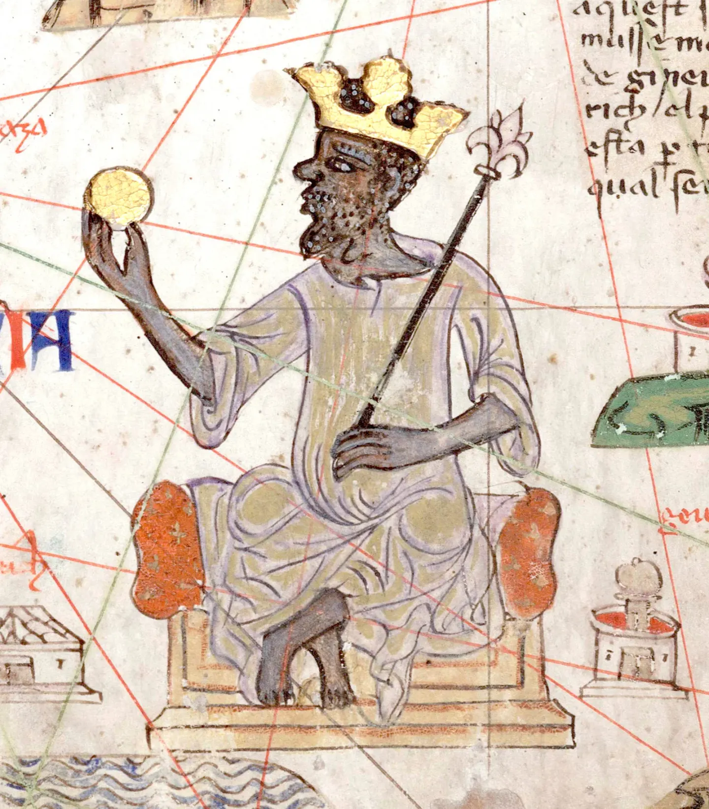
Mansa Musa of Mali on the Catalan Atlas, 1375 · Attributed to Abraham Cresques, 1375 / Bibliothèque nationale de France · Wikimedia Commons (public domain)
The slave trade crossing the Sahara was also vast. That trade triggered wars and shook several regions, and there were kingdoms that sustained their livelihoods from it (OpenStax World History Volume 2 3.4). A book on the trans-Saharan slave trade states in its blurb that this trade lasted from the seventh century to the twentieth century, sending nearly as many African people into subjugation in other lands as the Atlantic and East African slave trades, which were much busier over much shorter periods (DOI: 10.4324/9780203962817). Scale estimates vary among scholars.
Research suggests that at least Roman-era Sahara trade was a network of interlocking short segments, and along the roads of the Sahara, gold, salt, beliefs, and people captured as slaves were sold and dragged away.
The Disease Carried Along with Cargo
In the summer of 1347, ships leaving the Crimean trading city of Caffa reached Italian ports carrying disease (OpenStax World History Volume 1 16.3). The Black Death is the name for the pandemic of plague that spread across parts of Africa and Eurasia along maritime and overland trade routes in the 1340s. Yersinia pestis is the bacterium that causes the disease plague, and it is the very bacterium already identified as the cause of the 14th-century Black Death. Black rats traveled far along with the cargo of caravans and merchant ships. Rat fleas bit black rats and then moved to humans, serving as the main vector carrying the disease, and the most common form of plague was not directly contagious between humans (OpenStax World History Volume 1 16.3). The spread of black rats following humans goes back a long time. The distribution of several genetic lineages overlaps with human migration and trade routes confirmed by archaeology and records since prehistoric times (DOI: 10.1371/journal.pone.0026357).
As the disease spread, vast lands of Eurasia were ruled by the Mongol Empire and the states that split from it. A 2023 paper tentatively redraws the path the Black Death took starting from the Tian Shan region in Central Asia and heading west in two stages. It was slow from around 1338–1341 until 1345. This is thought to be because the political and commercial crises of the Mongol-related states and the natural conditions of the region acted as obstacles. It became fast between 1345 and 1346, when the disease reached the lands of the Golden Horde, one of the Mongol states. While the author considers that commercial networks connecting long-distance and short-distance routes played the biggest role in helping the spread, they do not claim to have solved the whole mystery (DOI: 10.1163/15685209-12341601).
Merchants were not the only ones who carried the disease. People fleeing famine and armies moving long distances also transported the disease (OpenStax World History Volume 1 16.3). The toll was heavy. In Europe, as many as 24 million people, roughly 30% of the population at the time, may have died. The Mamluk Sultanate, centered in Cairo, also lost about a third of its population. The long-standing picture that the disease spread mainly from east to west is also being shaken in the face of new evidence that it spread in many more directions. By 1409, the disease had also reached Indian Ocean ports in East Africa along maritime routes (OpenStax World History Volume 1 16.3).
The same routes carried cargo and disease alike. How fast and where the disease went was determined by a tangle of military movements, famine, political and commercial crises, and natural conditions, in addition to those commercial networks.
After 1492, Who Lost What and Why
In 1492, Christopher Columbus, an Italian navigator sailing for the Spanish crown, reached an island in the Caribbean. On one of those islands, Hispaniola, the Taíno people numbered at least several hundred thousand that year, but by 1514 only about 32,000 remained. Most died of disease, while some were killed by the Spanish or died from harsh labor as slaves (OpenStax World History Volume 2 5.4).
When widened to the whole of the Americas, the numbers become fuzzier. Around the time Columbus arrived, the indigenous population of the Americas is thought to have been roughly 75 million, but historians' estimates vary widely. Some scholars place the mortality rate as high as 95% when the indigenous people, who had no immunity, contracted newly introduced diseases. The sheer scale of indigenous deaths cannot be explained by disease alone. Famine weakened bodies so they could not fight off illness, and the loss of land and water alongside exposure to violence also added to the deaths. Even so, the indigenous people resisted and endured (OpenStax World History Volume 2 5.2).
These events are bundled under a single name. The Columbian Exchange is the name for the movement of diseases, crops, people, and ideas between the Americas and the rest of the world after Columbus's voyage in 1492. The same exchange changed the dining tables of other continents as well (DOI: 10.1257/jep.24.2.163). Corn and potatoes that crossed over from the Americas became staple foods in Europe, Africa, and Asia (OpenStax World History Volume 2 5.2).
The fact that crops crossed continents and changed diets was not entirely new in itself. There is research suggesting that the prehistoric Eurasian crop movements we saw earlier are comparable to the Columbian Exchange in the scale of their impact on diets (DOI: 10.1080/00438243.2011.624764). Research that re-examined why crops were moved points out that the earlier study overemphasized the usefulness of fast-growing crops, arguing instead that how people perceived and used the introduced crops changed over time and that social reasons often came first in the initial stages (DOI: 10.1080/00438243.2012.729404).
The Columbian Exchange changed the dining tables of other continents, but for the indigenous people of the Americas, it was a disaster of compounding disease, violence, and famine.
The Atlantic Route Where People Were Bought and Sold
On the 18th-century sugarcane plantations of the Caribbean, too many enslaved people died and babies had a hard time surviving, so plantation owners bought new people every year. When plantations called for people, that demand stretched across the sea to Africa like a chain (OpenStax World History Volume 2 5.4).
Slavery is a system that allowed certain people to be bought and sold like other people's property. In the Atlantic slave trade, human beings were bought and sold like commodities. From the late 15th century to the early 19th century, roughly 12 million African people were forcibly carried across the Atlantic to the Americas by Europeans, and about 2 million of them died on that voyage (OpenStax World History Volume 2 5.4).
The Middle Passage is the name given to the shipping route by which captured African people were carried across the Atlantic to the Americas. In the 18th century, 61,330 people crossed the Middle Passage every year, and among them 42% went to the Caribbean and 38% went to Brazil. People who went to the British North American mainland made up 4 to 5% of the total. As many as 500 to 600 people were loaded onto a single ship, and captains packed people in tighter even knowing that 10 to 20% would die along the way. In 1781, on the slave ship Zong, the captain had 132 people thrown alive into the sea on the grounds that insurance would not cover those who died of illness (OpenStax World History Volume 2 5.4).
Death aboard ship is the most visible and most widely discussed part of the harm done by the slave trade. Yet it was only one part of a movement that stretched from the place where people were captured in Africa to the place of forced labor in the Americas (DOI: 10.2307/2674420). The front end of the chain was inside Africa.
When European merchants offered big money and guns to buy people, the character of the slave trade within Africa changed. It was African slave traders and kingdoms that handed people over to European ships, and they waged wars and went deep inland to kidnap people in order to obtain people to capture. Guns were used in turn to capture even more people. The captured people died in large numbers even on the days-long trek to the coast (OpenStax World History Volume 2 5.4). Newly built states on the coast of the Gulf of Guinea, such as Ouidah and Dahomey, grew wealthy by handing over captives and became militarized (OpenStax World History Volume 2 3.4). Slavery had existed in Africa for a long time too, taking various forms such as cases where people were freed once they paid off a debt. Slavery that owned a person like an object for life existed in Africa as well, but only that single shape existed in the Americas (OpenStax World History Volume 2 5.4).
The harm did not end with the people who were dragged away. Since many of the carried-away people were young adults in their prime working years, the villages left behind lost hands for work and care all at once. According to one model estimate, the population from south of the Sahara to north of the Limpopo River did not grow between 1750 and 1850 due to the loss of people to the slave trade. A scholar's research introduced in textbooks views the region where the most people were dragged away—which was among the most developed places at the time—as having become today one of the poorest and most war-torn places in Africa (OpenStax World History Volume 2 5.4).
There is research suggesting that the wound also remained in trust between people. A 2011 study that matched modern individual surveys with slave-shipment records by ethnic group reports that the more heavily one's ancestors were subjected to slave raiding, the less one trusts others today. This is the result of looking at the Atlantic and Indian Ocean slave trades together. The authors view this relationship as causal, and consider that most of its influence passes through things rooted inside individuals, such as cultural norms and beliefs (DOI: 10.1257/aer.101.7.3221).
The dragged-away people rebuilt communities in the new land by calling each other family, and fought back by ruining work, running away, and staging uprisings (OpenStax World History Volume 2 5.4).
The Atlantic slave trade was a route where human beings were bought and sold like commodities, and its harms lingered long both in the people who crossed the sea and in the society left behind.
Unfolding the Transit Map Again
Now we place all the scenes we have looked at onto the transit map at once. At interchange stations like Samarkand, Kilwa, Timbuktu, and Yesongpo, silk, gold, salt, and porcelain changed hands. Along the same routes, Buddhism and Islam moved alongside merchants, and black rats and rat fleas traveled along with the cargo.
Trade routes have one difference from subway transit maps. A subway map is drawn by a single company, but no one drew the map of trade. The routes opened and closed according to winds, wars, and national bans. Examples include the Persian Gulf sea route taking over part of the overland routes, and Yesongpo losing its function due to the Ming Dynasty's bans. Also, while only long lines are drawn on transit maps, research revisiting the Sahara in Roman times suggests that trade crossing the entire long distance was only a small part, and exchanges of short and middle segments were interlocked.
And subway passengers buy their own tickets and ride. On the routes of the Indian Ocean, the Sahara, and the Atlantic, the people captured as slaves did not buy tickets. They were loaded in chains, and the slave traders' account books and Atlantic insurance counted them as "cargo."
Where to Look Next
Whether wages for European workers truly rose after the Black Death is examined by region and period in "Did Wages Really Rise After the Black Death? Where, When, and Whose". How to read the past through genes, much like the genetic lineages of the black rat, can be found in "What Genes Can Tell Us — An Old Book Copied Down the Generations".
How nations bound vast lands together through roads, taxes, and armies continues in "Empire — Many Peoples Bound by Roads, Taxes and the Sword", how cities where people gather came to be in "Cities and States — Where the First Maintenance Bills Arrived", and how machines and factories transformed the world in "The Industrial Revolution — The Factory Owner's Ledger and the Worker's Household Budget".
Source Papers
- "Silla's 'Seonbu' and the Maritime Silk Road" (2022) — DOI: 10.21490/jskh.2022.11.89.265 — Traces the utilization of the maritime silk road through the evolution of Silla's Seonbu and the spices, medicines, and dyes from Southeast Asia, India, and the Western Regions found in the 752 text "Selling Price List of Goods to Silla".
- "World History, Volume 1: to 1500 — 12.2 East-West Interactions in the Early Middle Ages" (2023) — OpenStax World History Volume 1 12.2 — The Silk Road was a network of multiple branches where goods changed hands at each segment; the Indian Ocean monsoon, the Swahili Coast, and the Zanj Rebellion.
- "World History, Volume 1: to 1500 — 12.3 Border States: Sogdiana, Korea, and Japan" (2023) — OpenStax World History Volume 1 12.3 — The Sogdians' takeover of oasis cities and the spread of Buddhism.
- "World History, Volume 1: to 1500 — 12.1 The Indian Ocean World in the Early Middle Ages" (2023) — OpenStax World History Volume 1 12.1 — Monsoons lengthened merchants' stays, aiding the spread of ideas.
- "Food globalization in prehistory" (2011) — DOI: 10.1080/00438243.2011.624764 — Starch crops appeared in various parts of Eurasia far from their origins during the second millennium BCE.
- "Exchanges of economic plants along the land silk road" (2022) — DOI: 10.1186/s12870-022-04022-9 — Wheat, barley, and jujubes entered China before the land route, while grapes, walnuts, and spinach entered along the land route; evidence conflicts for some crops.
- "Berenike and the Ancient Maritime Spice Route" (2011) — DOI: 10.1525/9780520948389 — Excavations of the Roman-era Red Sea port of Berenike show that maritime routes were as important as land routes.
- "The Persian Gulf in Late Antiquity" (2003) — DOI: 10.1353/jwh.2003.0005 — Argues that the Persia-Byzantium rivalry reduced land trade and increased Persian Gulf maritime trade in the 5th and 6th centuries.
- "Old World globalization and the Columbian exchange: comparison and contrast" (2012) — DOI: 10.1080/00438243.2012.729404 — Reassesses that social factors often predominated in the early stages of crop movement.
- "Silla Art and the Silk Road" (2014) — KCI ART001855484 — Confirms the influence of Western and western Chinese border cultures on Silla art through artifacts like the glass from Hwangnam Daechong.
- "Song Dynasty East Asian Maritime Trade and Monsoons: Focusing on the Route between Goryeo and Southern China" (2014) — KCI ART001923072 — Suggests the use of spring and fall northeastern winds based on the arrival timing of Song merchants at Yesonggang Port and the departure timing of Goryeo envoys; meteorological analysis requires additions.
- "Song-Goryeo Trade and Song Merchants: Focusing on Song Merchants' Management Forms and Their Goryeo Residential Quarters" (2009) — KCI ART001323829 — Ship-owning Song merchants' intermediation and transport, long-term residence in Goryeo, and intermarriage.
- "Maritime Trade Goods between Song China and Goryeo: An Examination through Comparison with the Southeast Asian Region" (2016) — DOI: 10.18347/hufshis.2016.60.151 — Estimates Goryeo's exports of ceramics and Goryeo cloth, imports of raw silk followed by the re-export of silk, and its role as a silver supplier.
- "Maritime Exchange and 'Haegum' in the Goryeo Dynasty" (2014) — KCI ART001888055 — Yesonggang Port lost its function due to the Ming Dynasty's maritime ban (haegum) policy.
- "World History, Volume 2: from 1400 — 3.1 The Roots of African Trade" (2022) — OpenStax World History Volume 2 3.1 — Salt and gold, the beginning of camel caravans and regular trade, Islam and credit/contracts, the forced conversion motive for the Amazigh people, Mali.
- "World History, Volume 1: to 1500 — 9.4 North Africa's Mediterranean and Trans-Saharan Connections" (2023) — OpenStax World History Volume 1 9.4 — The timing of the introduction and spread of the dromedary camel in North Africa.
- "Saharan trade in the Roman period: short-, medium- and long-distance trade networks" (2012) — DOI: 10.1080/0067270x.2012.727614 — Roman-era Saharan trade was a network of short-, medium-, and long-distance subsystems, larger than thought, with slaves likely playing a major role.
- "Trade in the Ancient Sahara and Beyond" (2017) — DOI: 10.1017/9781108161091 — Although core trade goods are not readily visible archaeologically, the pre-Islamic Sahara was more connected than thought.
- "World History, Volume 2: from 1400 — 3.4 The Trans-Saharan Slave Trade" (2022) — OpenStax World History Volume 2 3.4 — Wars triggered by the slave trade and kingdoms reliant on them, Ouidah and Dahomey's supply of captives and militarization.
- "World History, Volume 1: to 1500 — 16.3 The Black Death from East to West" (2023) — OpenStax World History Volume 1 16.3 — Black rats and rat fleas, Kaffa to Italy, armies and refugees, European mortality estimates, Mamluk population loss, diversity in the directions of spread.
- "Multiple Geographic Origins of Commensalism and Complex Dispersal History of Black Rats" (2011) — DOI: 10.1371/journal.pone.0026357 — Black rat genetic lineage distributions overlap with human migration and trade routes from prehistoric times.
- "From the Tian Shan to Crimea: Dynamics of Plague Spread during the Early Stages of the Black Death, 1338–46" (2023) — DOI: 10.1163/15685209-12341601 — Tentative reconstruction: slow and fast stages, commercial networks playing the largest role, acknowledgment of unresolved questions.
- "World History, Volume 2: from 1400 — 5.2 Crossing the Atlantic" (2022) — OpenStax World History Volume 2 5.2 — Conflicting native population estimates, multiple causes of death and resistance, the spread of American crops.
- "World History, Volume 2: from 1400 — 5.4 The Atlantic Slave Trade" (2022) — OpenStax World History Volume 2 5.4 — Approximately 12 million people forcibly transported with about 2 million deaths during the voyage, Caribbean plantation populations, destination ratios, conditions on ships and tight packing, changes in internal African trade, damage to remaining societies, resistance.
- "The Columbian Exchange: A History of Disease, Food, and Ideas" (2010) — DOI: 10.1257/jep.24.2.163 — Overview of the post-1492 exchange of diseases, crops, knowledge, and populations between the Old and New Worlds, particularly the long-term impact on the Old World side.
- "The Trans-Saharan Slave Trade" (2007) — DOI: 10.4324/9780203962817 — A book (publisher's introduction) stating that the 7th- to 20th-century Saharan slave trade sent numbers into servitude roughly matching the Atlantic and East African slave trades.
- "Transoceanic Mortality: The Slave Trade in Comparative Perspective" (2001) — DOI: 10.2307/2674420 — On-board mortality on the Middle Passage is the most visible part, but it is just one part of the journey from capture to forced labor, compared with other oceanic voyages.
- "The Slave Trade and the Origins of Mistrust in Africa" (2011) — DOI: 10.1257/aer.101.7.3221 — People whose ancestors suffered severe slave raiding are less trusting today, judged as causality, mostly mediated by internal individual factors such as cultural norms.
Sources (24)
- 신라의 '船府'와 해상 실크로드DOI 10.21490/jskh.2022.11.89.265
- World History, Volume 1: to 1500 — 12.2 East-West Interactions in the Early Middle Ages
- World History, Volume 1: to 1500 — 12.3 Border States: Sogdiana, Korea, and Japan
- World History, Volume 1: to 1500 — 12.1 The Indian Ocean World in the Early Middle Ages
- Food globalization in prehistoryDOI 10.1080/00438243.2011.624764
- Exchanges of economic plants along the land silk roadDOI 10.1186/s12870-022-04022-9
- Berenike and the Ancient Maritime Spice RouteDOI 10.1525/9780520948389
- The Persian Gulf in Late AntiquityDOI 10.1353/jwh.2003.0005
- Old World globalization and the Columbian exchange: comparison and contrastDOI 10.1080/00438243.2012.729404
- 宋代 中國과 高麗 사이의 海上 交易品 - 東南아시아 地域과의 比較를 통한 檢討DOI 10.18347/hufshis.2016.60.151
- World History, Volume 2: from 1400 — 3.1 The Roots of African Trade
- World History, Volume 1: to 1500 — 9.4 North Africa's Mediterranean and Trans-Saharan Connections
- Saharan trade in the Roman period: short-, medium- and long-distance trade networksDOI 10.1080/0067270x.2012.727614
- Trade in the Ancient Sahara and BeyondDOI 10.1017/9781108161091
- World History, Volume 2: from 1400 — 3.4 The Trans-Saharan Slave Trade
- World History, Volume 1: to 1500 — 16.3 The Black Death from East to West
- Multiple Geographic Origins of Commensalism and Complex Dispersal History of Black RatsDOI 10.1371/journal.pone.0026357
- From the Tian Shan to Crimea: Dynamics of Plague Spread during the Early Stages of the Black Death, 1338–46DOI 10.1163/15685209-12341601
- World History, Volume 2: from 1400 — 5.2 Crossing the Atlantic
- World History, Volume 2: from 1400 — 5.4 The Atlantic Slave Trade
- The Columbian Exchange: A History of Disease, Food, and IdeasDOI 10.1257/jep.24.2.163
- The Trans-Saharan Slave TradeDOI 10.4324/9780203962817
- Transoceanic Mortality: The Slave Trade in Comparative PerspectiveDOI 10.2307/2674420
- The Slave Trade and the Origins of Mistrust in AfricaDOI 10.1257/aer.101.7.3221