Paperis Articles
Plate Tectonics — Ice Floes That Jostle, and the Rock That Flows Beneath
How we see inside Earth with seismic waves, the evidence that plates move, where earthquakes and volcanoes cluster, and earthquakes on the Korean Peninsula, inside a plate
Your field's papers, as audio
Pick your fields and journals — Paperis summarizes the key papers and turns them into audio. Listen on your commute.
Start Paperis free →Plate Tectonics — Ice Floes That Jostle, and the Rock That Flows Beneath
A Day When the Ground Shook Underfoot
On September 12, 2016, the ground shook around Gyeongju, Gyeongsangbuk-do. It was the largest instrumental earthquake recorded in South Korea until then, followed by nearly 600 smaller tremors (DOI: 10.14770/jgsk.2017.53.3.407). Just over a year later, on November 15, 2017, the ground shook again in nearby Pohang (DOI: 10.7582/GGE.2018.21.2.125).
Why does the ground shake, why there of all places, and how were mountains and oceans formed? This article unpacks these questions by looking at the inside and outside of the Earth. The principles apply everywhere on Earth, and the examples are drawn from the Korean Peninsula as much as possible.
As our guide, we take only a single sheet of ice on a river in early spring. When the river thaws, the ice breaks into several pieces. In the widening gaps, new ice freezes; where they collide, one edge slides underneath or the two overlap and rise; and where they brush past each other, the pieces catch and release, creaking. The Earth's crust is also fragmented like this, and those pieces are still moving today.
Looking Inside the Earth Through Tremors
No one has ever gone deep into the Earth. Yet how do we know there is melted metal in the middle of the Earth? The answer lies in the tremors sent by earthquakes. Seismic waves are tremors caused by earthquakes or explosions that travel through the inside of the Earth.
Among seismic waves, there are shear waves. Shear waves are waves where the direction of the tremor is perpendicular to the direction the wave travels. Earthquake shear waves pass through solid rock but cannot pass through liquid, stopping at the boundary of the deep underground liquid layer. Therefore, on the opposite side of the Earth from where an earthquake occurred, a wide shadow appears where shear waves do not reach, and the depth where the liquid layer begins is calculated backward from the size of that shadow (Steven Earle, Physical Geology, 2nd Edition ch. 9.01).
When we draw the Earth this way, looking from the inside out, it is like this. The innermost part is the metal core. The outer core is the outer part of the metal core starting from a depth of 2,900 kilometers, and it is in a melted liquid state. The sphere about 2,400 kilometers in diameter inside it is believed to be solid, and the core is thought to be mostly iron mixed with nickel and other elements. The mantle is the largest layer of the Earth, extending from above the core to beneath the crust, and it is mostly solid but is a rocky layer that can flow very slowly. The crust is the outermost, thin rocky shell covering the mantle. The crust beneath the ocean is about 6 kilometers thick, and the continental crust is 20 to 70 kilometers thick (OpenStax Astronomy 2e 8.1).
The outer core is also connected to the compass. The liquid iron of the outer core moves and creates the Earth's magnetic field. For reasons not yet fully understood, this magnetic field has repeatedly weakened and revived, and at those times, the north and south poles flipped. Over the past 250 million years, this has happened hundreds of times, at irregular intervals (Steven Earle, Physical Geology, 2nd Edition ch. 9.03). The inside of the Earth is seen through the way tremors pass through it, and the Earth seen that way is a layered structure of a metal core, slowly flowing rocks, and a thin shell.
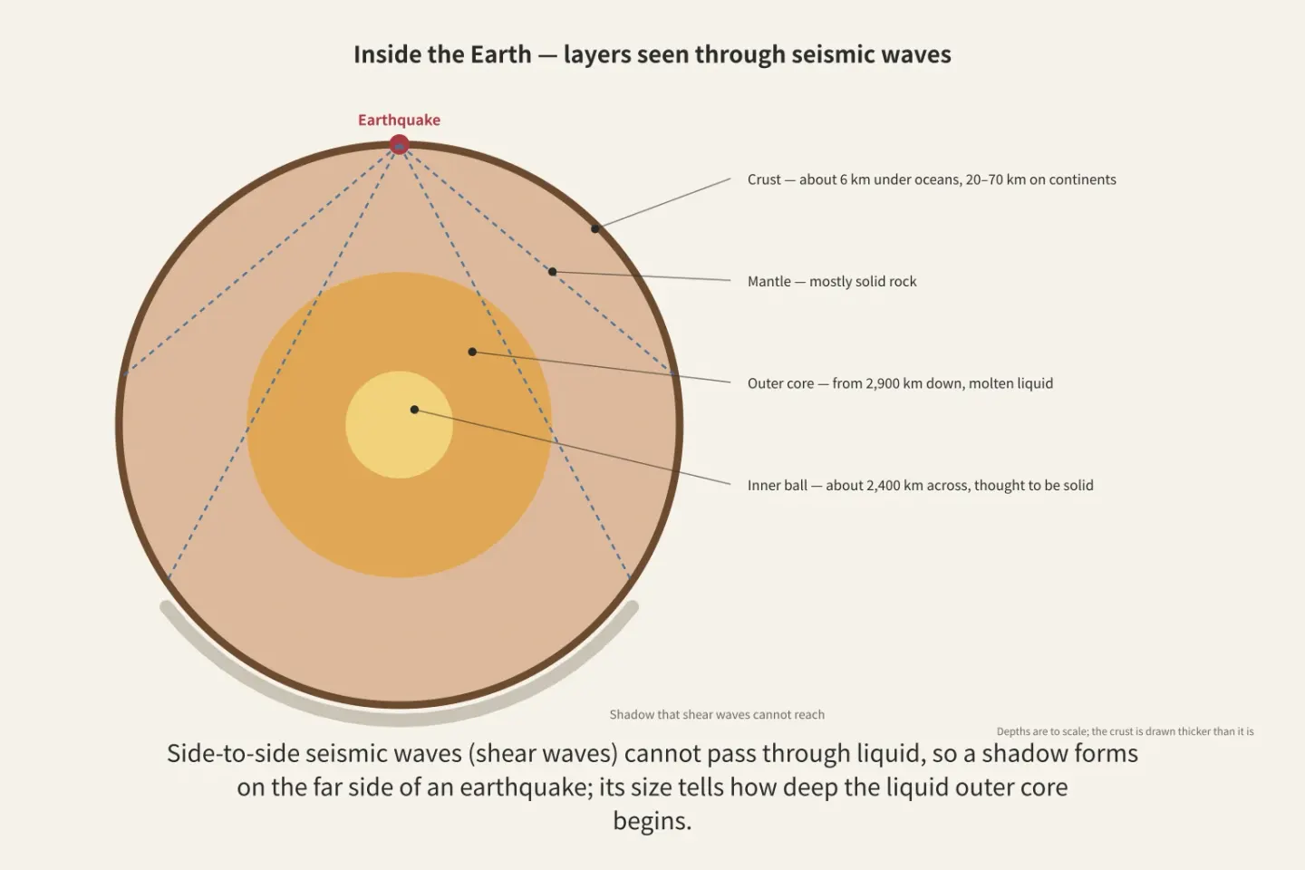
Figure: a diagram Paperis drew using only what the article says
Fragmented Earth Crust
The equivalent of river ice chunks is plates. A plate is a rigid piece formed by the crust and the upper part of the mantle stuck together, and Earth's surface is divided into a dozen or so such pieces. The thickness of a plate is estimated to be roughly 60 kilometers (OpenStax Astronomy 2e 8.2), and underneath it lies a partially melted, less rigid layer, which is thought to allow the plate to slide over it. Because a plate includes the upper mantle, a single plate can carry both continents and the ocean floor (Steven Earle, Physical Geology, 2nd Edition ch. 10.04).
Between a few large plates like the Eurasian, Pacific, and North American plates, there are several smaller plates. The large plates move at different speeds, ranging from less than 1 centimeter to over 10 centimeters per year (Steven Earle, Physical Geology, 2nd Edition ch. 10.04).
What makes the plates move? There is accumulated heat inside the Earth, and the plates move along the path where that heat escapes outward. Plate tectonics is the explanation that slow movements within the mantle move the plates, shifting continents and creating major landforms such as mountain ranges and oceans. In the mantle, warm rock slowly rises and cooled rock slowly sinks, carrying heat outward, and the plates move at the very top of that flow. Therefore, plate tectonics can also be read as a cooling device by which the Earth sends its internal heat out into space (OpenStax Astronomy 2e 8.2). There are other explanations regarding where a large share of the force comes from. One review paper summarizes that the pulling force of heavy plates sinking into the mantle provides most of the force that moves the plates (DOI: 10.1029/2001rg000108). The Earth's crust consists of rigid pieces attached down to the upper mantle, and the heat inside the Earth moves those pieces.
Evidence That It Moved
The claim that continents move was published as a book in 1915 by the German scientist Alfred Wegener, but because he could not explain what moves solid continents, he faced fierce opposition from most scholars (OpenStax Astronomy 2e 8.2). Continental drift is the claim that continents now apart were once a single mass and subsequently slowly drifted apart. He presented evidence, but the mechanism of how they moved was missing.
What filled that vacancy was the ocean floor. In the middle of the Atlantic Ocean lies a mountain range stretching across the ocean floor, where two plates pull apart (OpenStax Astronomy 2e 8.2). Seafloor spreading is the process where molten rock rising from below fills the gap at an undersea mountain range where two plates pull apart, becoming new ocean floor and widening the ocean bottom on both sides. This is analogous to new ice freezing in an open crack in river ice (OpenStax Astronomy 2e 8.2; Steven Earle, Physical Geology, 2nd Edition ch. 10.04).
When the idea that the ocean floor widens this way was first proposed, it was not widely accepted, partly due to a lack of solid evidence. The thickness of ocean-floor sediments did not contradict this idea. Near the continents, they were thousands of meters thick, but near the mountain range, they were thin or absent entirely (Steven Earle, Physical Geology, 2nd Edition ch. 10.03).
If this idea is correct, traces must remain in the rocks. When molten rock cools and solidifies, the magnetite grains within it preserve the direction of Earth's magnetic field at that time (Steven Earle, Physical Geology, 2nd Edition ch. 10.03). If so, the ocean floor newly solidified at the mountain range and pushed outward to both sides should have bands consecutively imprinted with reversed directions every time the magnetic field flipped. If both sides widen at the same speed, the bands on either side of the mountain range should be mirror images of each other.
In 1963, British researchers Fred Vine and Drummond Matthews, following Canadian geologist Lawrence Morley by a few months, explained the strong and weak magnetic bands measured in seafloor rocks in precisely this way. As it was confirmed in undersea mountain ranges across the world that the sequence of bands matched the timeline of geomagnetic reversals, this interpretation gained strong support (Steven Earle, Physical Geology, 2nd Edition ch. 10.03). In actual oceans, the two sides do not always widen at the exact same width, so some oceans have widened more to one side (DOI: 10.1029/92jb02280).
Based on magnetic striping, the average age of the current oceanic crust is roughly 64.2 million years (DOI: 10.1029/2020gc009214). A little over 100 million years is enough for the entire ocean floor to be renewed, making the ocean floor one of the youngest landforms on Earth (OpenStax Astronomy 2e 8.2). The ideas of continental drift and seafloor spreading were widely accepted around 1965 (Steven Earle, Physical Geology, 2nd Edition ch. 10.04). The ocean floor is still being newly created today, and the magnetic stripes imprinted by rocks provided solid evidence for continental drift to grow into plate tectonics.
Three Places Where Plates Meet
Just as there are three ways ice floes meet, there are three types of plate boundaries (Steven Earle, Physical Geology, 2nd Edition ch. 10.04).
The first is where they pull apart. A divergent boundary is a boundary where two plates move away from each other. Most are found beneath the oceans, with only a few on land (OpenStax Astronomy 2e 8.2). Along divergent boundaries, earthquakes are common, but they are concentrated in a narrow band near the mountain ranges and are shallower than 30 kilometers. In the segments where the seafloor is actively pulling apart, rocks are hot, so earthquakes are usually small and rare (Steven Earle, Physical Geology, 2nd Edition ch. 11.02).
The second is where they collide. A convergent boundary is a boundary where two plates approach each other. When one of the two plates is an ocean floor plate, that plate goes downward. Subduction is the process at a convergent boundary where one plate dives beneath another plate and descends into the mantle. Usually, the older, colder, and heavier side goes underneath (Steven Earle, Physical Geology, 2nd Edition ch. 10.04), and a deep submarine trench forms in that spot (OpenStax Astronomy 2e 8.2).
At subduction zones, earthquakes are very frequent and occur at increasingly deeper locations the further inland you go (Steven Earle, Physical Geology, 2nd Edition ch. 11.02). When two continents collide, the situation is different. Continents are light and do not go underneath; instead, the rocks crumple and rise to form high mountain ranges. The Himalayas formed this way (Steven Earle, Physical Geology, 2nd Edition ch. 10.04).
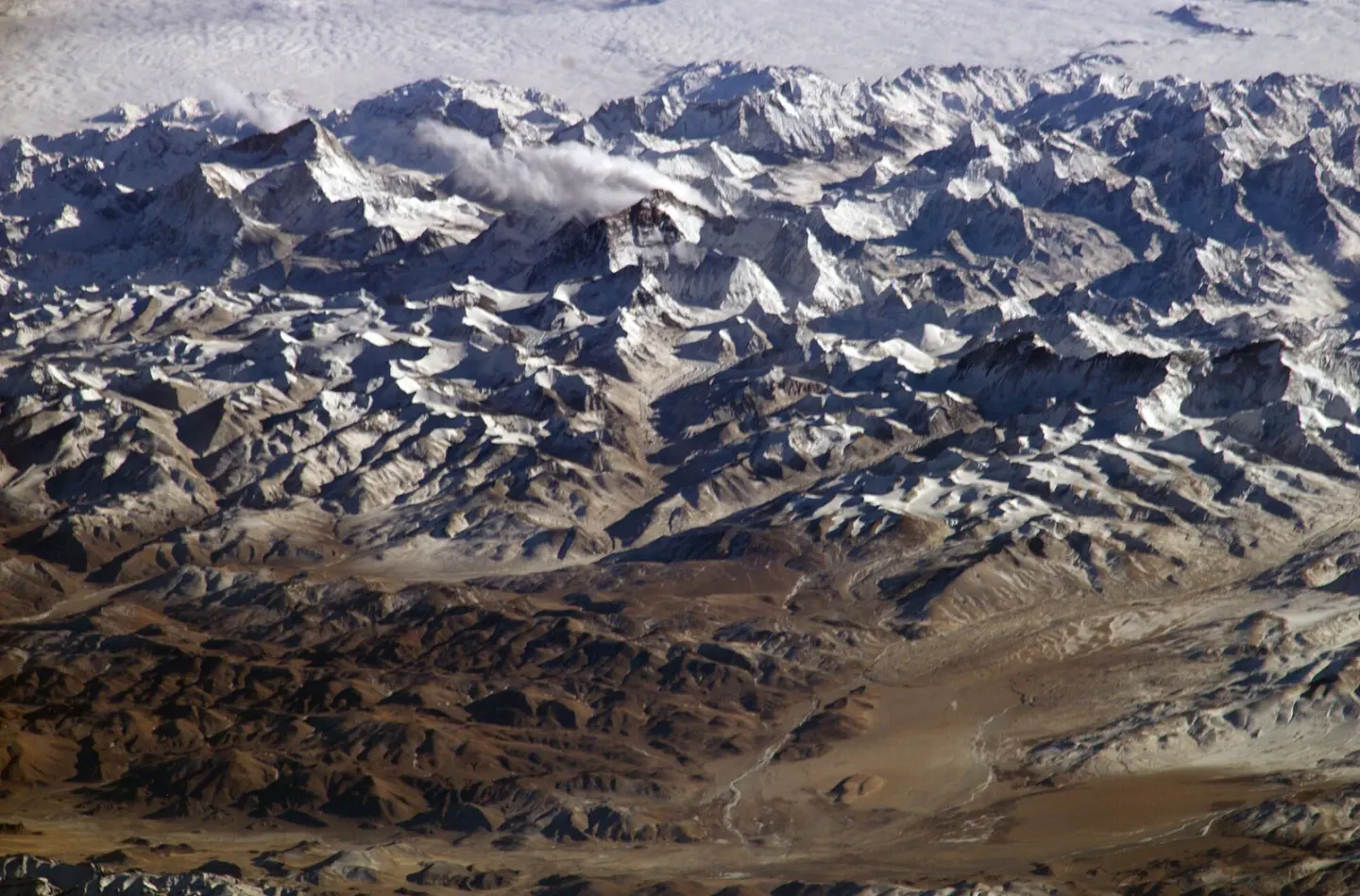
The Himalaya seen from the International Space Station · NASA · Wikimedia Commons (public domain)
The third is where they brush past each other. A transform boundary is a boundary where two plates slide past one another horizontally without creating or destroying Earth's crust. Most of them connect segments of underwater mountain ranges, and some cut across continents (Steven Earle, Physical Geology, 2nd Edition ch. 10.04). Shallow earthquakes are common here, and many of the earthquakes around divergent boundaries occur along these transform boundaries that connect mountain range segments (Steven Earle, Physical Geology, 2nd Edition ch. 11.02).
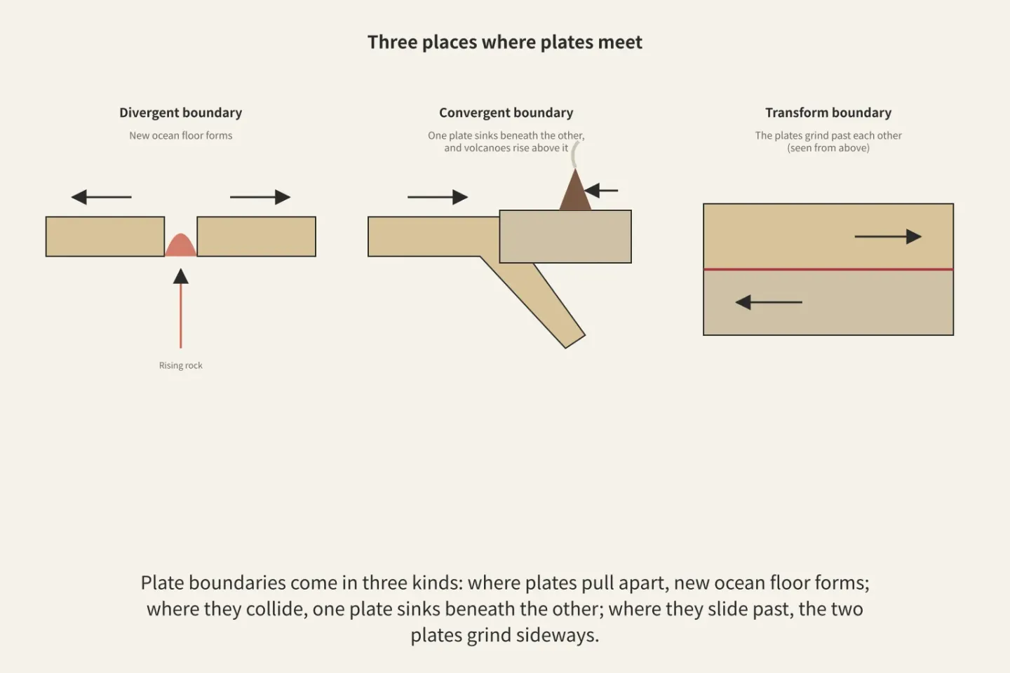
Figure: a diagram Paperis drew using only what the article says
If you open a world earthquake map, it is easy to see that earthquakes and plate boundaries overlap (Steven Earle, Physical Geology, 2nd Edition ch. 11.02). However, earthquakes are also relatively common in a few places inside plates, and why some of them happen is still not well understood (Steven Earle, Physical Geology, 2nd Edition ch. 11.02). Earthquakes do not happen randomly anywhere but are concentrated at plate boundaries, and the depth and magnitude at which they occur vary depending on the type of boundary.
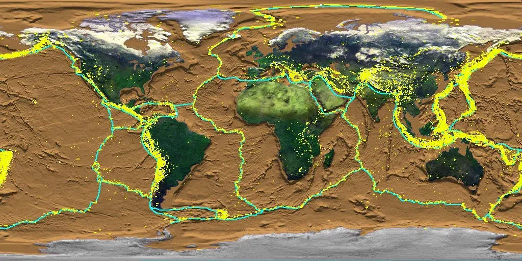
Earthquake epicenters (yellow) and plate boundaries (teal) worldwide · NASA HoloGlobe Project · Wikimedia Commons (public domain)
Two Numbers That Measure the Size of an Earthquakes
At plate boundaries, two contacting plates catch and hold against each other. As the plates slowly push, force accumulates, and the moment they can no longer withstand that force, the rocks slip all at once, causing an earthquake (OpenStax Astronomy 2e 8.2). This is like sheets of ice catching and releasing with a creak. The surface where they slip is a fault. A fault is a location where both sides have shifted out of place along a fracture plane in the rock. Even far from plate boundaries, earthquakes occur when faults suddenly slip (DOI: 10.14770/jgsk.2017.53.3.407).
Earthquake news reports feature two numbers. Magnitude is an estimate of the energy released by an earthquake, and a single number is assigned to each earthquake. When magnitude increases by 1, the energy released increases by 32 times. There are various ways to measure it, and nowadays, a method called moment magnitude is used more widely. This is because it provides a more accurate estimate, especially for large earthquakes (Steven Earle, Physical Geology, 2nd Edition ch. 11.03). All very large earthquakes exceeding magnitude 9 occur at boundaries where a plate subducts underneath (Steven Earle, Physical Geology, 2nd Edition ch. 11.02).
Intensity is a value assigned based on how strongly people felt the shaking and how much damage occurred at a given location, meaning that even for the same earthquake, intensity varies from place to place. Intensity depends on how close the location is to the earthquake, whether the subsurface is hard rock or soft soil, and what kinds of buildings are standing there (Steven Earle, Physical Geology, 2nd Edition ch. 11.03).
Gyeongju and Pohang demonstrate that the two numbers are different. Because the values of magnitude differ slightly depending on the measurement method, values are only compared within the same method. Measured by local magnitude ($M_L$), the Pohang earthquake was 5.4 and the Gyeongju earthquake was 5.8 (DOI: 10.12652/Ksce.2019.39.6.0821).
In a study recorded using moment magnitude, Gyeongju was 5.4 and Pohang was 5.5, making the two nearly identical (DOI: 10.5000/EESK.2018.22.6.323). The Pohang earthquake—which was smaller in local magnitude yet nearly identical in moment magnitude—caused the greatest economic and human casualties in the country since instrumental record-keeping began, according to a 2019 study (DOI: 10.9798/KOSHAM.2019.19.1.289).
A study that sought the reason for this in the effect of the depth where the earthquake started estimated the spot where the slip began to be around 7 kilometers underground, though it noted that the exact depth is not yet confirmed (DOI: 10.7582/GGE.2018.21.2.125). Magnitude is the size of a single earthquake, and intensity is how strongly that earthquake felt right where I am.
There is also an order to why earthquake alerts arrive quickly. When an earthquake happens, faster shaking reaches monitoring stations first, and the shaking that causes more damage often arrives several seconds later. If magnitude is measured using the shaking that arrives first, an earthquake that has already begun can be announced rapidly (Steven Earle, Physical Geology, 2nd Edition ch. 11.03). South Korea also operates an early warning system using real-time observations (KCI ART003378941). An early warning is an alert about an earthquake that has already started, delivered before the heavy shaking arrives.
Where Volcanoes Stand
The places where volcanoes stand are also connected to plates. There are broadly three places where rock melts: where plates pull apart, where one plate goes underneath another, and where hot columns of rock rise from deep within the earth (Steven Earle, Physical Geology, 2nd Edition ch. 4.01).
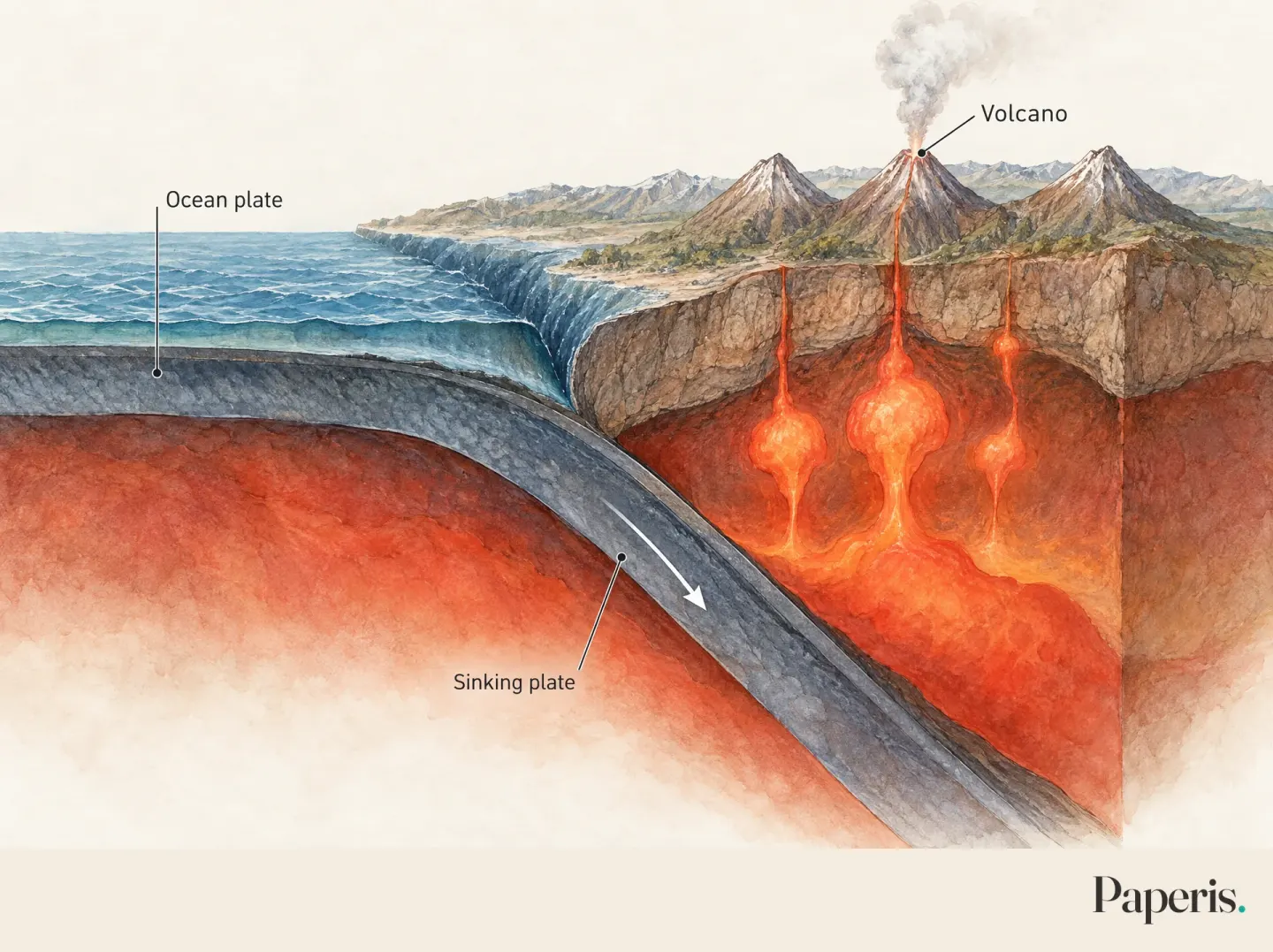
Illustration: Paperis
Where plates pull apart, hot mantle rock slowly rises, the pressure weighing down on it decreases, and thanks to that, part of it melts (Steven Earle, Physical Geology, 2nd Edition ch. 4.01). The places where plates go underneath are different from intuition. It is easy to think they melt from the heat generated by plates rubbing against each other, and in a study surveying 140 students, more than 90% answered that way (DOI: 10.21796/jse.2008.32.2.121). In reality, as the descending plate warms up, it releases water from its minerals, and that water rises into the upper mantle, lowering the temperature at which the rock melts. At that depth beneath a volcano, the descending plate itself is not hot enough to melt (Steven Earle, Physical Geology, 2nd Edition ch. 4.01). The rock melted in this way surges up, and volcanoes line up along the subduction zone (DOI: 10.1029/2001rg000108).
Traces of a plate going down are also caught by seismic waves near the Korean Peninsula. When mapping the interior of China and its surroundings using records from 19,000 earthquakes, the Pacific plate that descended from an oceanic trench continued down to a depth of around 600 kilometers, and beneath eastern China, it lay resting at that depth (DOI: 10.1029/2005jb004066). The same study found a zone where seismic waves pass slowly in the mantle above the lying Pacific plate, beneath the volcanoes in northeastern China—including Mount Baekdu (known in China as Changbaishan)—standing inside the plate, and based on this, it put forward the interpretation that these volcanoes are related to the deeply descended Pacific plate (DOI: 10.1029/2005jb004066). This means that even volcanoes far from plate boundaries can be linked to plate movements.
The Korean Peninsula Inside the Plate
The Korean Peninsula is located inside the Eurasian plate. Earthquakes are rarer here than at plate boundaries, but the reasons why earthquakes occur and how often they repeat are complex, creating an environment where large earthquakes can occur infrequently (KCI ART003378943).
Even though they are rare, the records are numerous. Historical documents have gathered roughly 2,200 earthquakes on the Korean Peninsula. Earthquakes occurred across the entire peninsula, though they were relatively scarce in the northeast and exceptionally frequent from the 15th to 18th centuries (KCI ART003378941). The sites of major historical earthquakes overlap well with large faults created by ancient tectonic movements (KCI ART003378941).
Earthquakes inside plates do not happen just anywhere, either. In a study that analyzed only the statistical distribution of magnitude 3 or greater earthquakes from 1978 to 2016, earthquakes on the Korean Peninsula were concentrated in specific regions forming an L-shape, with Pohang, Gyeongju, Ulsan, and Busan grouped into a single dense cluster. The authors considered the probability of a large earthquake occurring at any time in this region to be high. However, because this judgment came from compiling past earthquake locations statistically without geological knowledge, it did not calculate when or how large future earthquakes would be (KCI ART002388811).
Fault line maps and earthquake locations do not always match up, either. The same statistical study found no high correlation between the density of earthquakes and the density of fault lines (KCI ART002388811), and the discrepancy between faults exposed on the surface and faults actually generating earthquakes underground is cited as an issue in seismic risk assessment (KCI ART003378943). Regarding the Gyeongju earthquake, there is a preliminary study concluding that a branch fault within the fractured zone west of the Yangsan Fault moved (DOI: 10.14770/jgsk.2017.53.3.407).
What remains unknown about the earthquakes of the Korean Peninsula is also clearly documented. Because it is difficult to identify faults capable of generating earthquakes, the period of instrumental measurement is short, and reading historical records involves uncertainty, it is difficult to finalize a single model for where and how earthquakes will occur. Another key issue is how to distinguish and handle earthquakes induced or triggered by human activity from risk assessments based on long-term natural earthquakes (KCI ART003378943). Because the Korean Peninsula is inside a plate, earthquakes are rare but not absent, and where and why they happen has not yet been fully determined.
Back to River Ice
The ice-sheet metaphor has been useful this far, but it differs from actual land in four places. First, beneath the ice sheet is liquid water. The mantle beneath the plates is mostly solid rock, and that rock flows slowly over very long periods of time (OpenStax Astronomy 2e 8.1). Even the layer directly beneath where the plates slide is only partially melted and less rigid (Steven Earle, Physical Geology, 2nd Edition ch. 10.04). That is what "flowing rock" in the title means. Second, gaps of exposed water remain between ice sheets, but wide gaps are never left remaining between plates (Steven Earle, Physical Geology, 2nd Edition ch. 10.04). As much as they pull apart, melted rock rises from below to fill the space. Third, ice sheets are made only of ice, but plates are chunks composed of the crust attached to the upper part of the mantle. Fourth, ice sheets drift downstream in one direction carried by river current, whereas plates each move in different directions and at different speeds, and there is also the theory that a large share of that force is supplied by the plate itself sinking into the mantle (DOI: 10.1029/2001rg000108).
To sum up, the Earth as peered into through seismic waves is a layer of a metallic core, a slowly flowing mantle, and a thin crust, and its surface is split into plates that move around a few centimeters or so every year. Earthquakes and volcanoes cluster at the boundaries where plates pull apart, collide, and scrape past each other, and earthquakes also occur rarely on the Korean Peninsula inside a plate.
Where to Look Next
How buildings withstand the shaking of earthquakes is continued in "Wind and Earthquakes — Wind Pushing at the Side, Jelly Wobbling with Its Plate". How heat moves within the Earth is covered in "Heat and Temperature — Water That Only Flows Downhill, a Pump That Lifts It Back Up", and radioactive decay, another way to measure the age of rocks, is covered in "Atoms and Radiation — A Drizzle That Never Stops, a Rain Gauge for How Wet We Get". How science debates the eruption timing of a single volcano can be seen in "When Did the Thera Volcano Erupt? — The Century Between Carbon and Pottery". The story of carbon trapped for a long time in rocks and the ocean continues in another installment of this series, "The Carbon Cycle — Jars Buried in the Yard, a Winter Room with Sealed Door Gaps".
Source Papers
- "Astronomy 2e — 8.1 The Global Perspective" (2022) — OpenStax Astronomy 2e 8.1 — Earth's diameter is roughly 12,760 km, and direct knowledge covers only the outer few km, while seismic wave transmission, refraction, and shadow zones yield liquid and solid layer models; crust thickness (oceanic roughly 6 km, continental 20 to 70 km) and mass 0.3%, mantle is mostly solid down to 2900 km but flows slowly, core starts from 2900 km with liquid outer core and inner core (diameter roughly 2400 km) likely solid iron and nickel, and magnetic field is generated by movement in the liquid metal outer core.
- "Astronomy 2e — 8.2 Earth's Crust" (2022) — OpenStax Astronomy 2e 8.2 — Meaning of plate tectonics, crust plus upper mantle (roughly 60 km) split into roughly 12 plates, slow mantle movement acts as power source and Earth's cooling mechanism, Wegener's 1915 book and shorelines and fossils and Pangaea met cold reception due to lack of mechanism, molten rock fills gaps at rifts, oceanic crust is renewed in barely 100 million years making it the youngest terrain, thick continents are not subducted, Japan Trench, slow plate movement builds up stress leading to sudden slip and earthquakes.
- "Physical Geology, 2nd Edition — 10.04 Plate, Plate Motions, and Plate Boundary Processes" (2026) — Steven Earle, Physical Geology, 2nd Edition ch. 10.04 — Accepted around 1965, plate map by late 1967, 8 major plates, speeds under 1 cm to over 10 cm per year, three types of boundaries, no gaps between plates, plate = crust + lithospheric mantle sliding over partial melt layer, single plate contains both continental and oceanic crust, older and colder plates subduct, continents do not subduct and form mountain ranges (Himalayas), transform boundaries involve no crust creation or destruction and mostly connect segments of mid-ocean ridges, seafloor magnetic dating reconstructs Pangaea breakup.
- "Physical Geology, 2nd Edition — 11.02 Earthquakes and Plate Tectonics" (2026) — Steven Earle, Physical Geology, 2nd Edition ch. 11.02 — Relationship between earthquakes and plate boundaries, divergent boundary earthquakes form a narrow band under 30 km deep and are small and rare, transform boundaries have shallow earthquakes, subduction zones have frequent earthquakes that get deeper toward land, magnitudes of 9 or higher all occur at subduction boundaries, and some earthquakes inside plates are not well understood.
- "Physical Geology, 2nd Edition — 11.03 Measuring Earthquakes" (2026) — Steven Earle, Physical Geology, 2nd Edition ch. 11.03 — Magnitude estimates radiated energy and "Richter scale" is an incorrect name, intensity assesses feelings and damage location by location and varies by distance, ground, and buildings, each magnitude step multiplies energy by 32, and earlier-arriving waves provide rapid alerts for earthquakes already underway.
- "Physical Geology, 2nd Edition — 4.01 Plate Tectonics and Volcanism" (2026) — Steven Earle, Physical Geology, 2nd Edition ch. 4.01 — Magma forms at divergent boundaries (decompression), convergent boundaries (water lowers melting point), and mantle plumes, while the subducting crust itself does not melt but releases water.
- "Physical Geology, 2nd Edition — 9.01 Understanding Earth Through Seismology" (2026) — Steven Earle, Physical Geology, 2nd Edition ch. 9.01 — S-waves cannot pass through liquids so they stop at the core-mantle boundary and create a shadow opposite the hypocenter whose size is used to estimate boundary depth, while P-waves passing through liquids refract at the core boundary to create another shadow revealing differences inside and outside the core.
- "Physical Geology, 2nd Edition — 9.03 Earth's Magnetic Field" (2026) — Steven Earle, Physical Geology, 2nd Edition ch. 9.03 — Magnetic field is generated by convection of liquid iron in the outer core and is unstable over geological time, weakening, regenerating, and occasionally reversing polarity, happening hundreds of times over the past 250 Ma at irregular intervals.
- "Physical Geology, 2nd Edition — 10.03 Geological Renaissance of the Mid-20th Century" (2026) — Steven Earle, Physical Geology, 2nd Edition ch. 10.03 — Magnetite in solidifying magma becomes magnetized in the direction of the magnetic field at that time (remnant magnetism), sediments are thousands of meters thick near continents and thin or absent near mid-ocean ridges, Hess's seafloor spreading theory lacked sufficient evidence and was not widely accepted, seafloor magnetic anomaly stripes were collected starting in 1958 but remained unexplained, Vine-Matthews (and Morley) explained the stripes in 1963 as magnetic reversals with Vine focusing on mid-ocean ridge symmetry, and within a few years identical patterns and reversal chronology matches were confirmed across global mid-ocean ridges providing strong support.
- "한반도 과거 지진기록에 대한 응답이력 데이터베이스 구축 기초 연구" (2019) — DOI: 10.12652/Ksce.2019.39.6.0821 — Gyeongju earthquake (2016.9.12., ML=5.8) and Pohang earthquake (2017.11.15., ML=5.4).
- "SUBDUCTION ZONES" (2002) — DOI: 10.1029/2001rg000108 — Overview of subduction zones (Reviews of Geophysics review): excess density of subducting plates provides most of the force moving plates, and interaction between water rising from the sinking plate and the mantle causes melting to erupt as island arc volcanoes.
- "Updated interpretation of magnetic anomalies and seafloor spreading stages in the south China Sea: Implications for the Tertiary tectonics of Southeast Asia" (1993) — DOI: 10.1029/92jb02280 — South China Sea magnetic cross-section interpretation: seafloor spreading was asymmetric and the spreading axis shifted at least once.
- "A Global Data Set of Present‐Day Oceanic Crustal Age and Seafloor Spreading Parameters" (2020) — DOI: 10.1029/2020gc009214 — Oceanic crust age grid updated with magnetic anomaly readings and plate tectonic models, with an average age of 64.2 Myr (slightly older than previous estimates).
- "High‐resolution mantle tomography of China and surrounding regions" (2006) — DOI: 10.1029/2005jb004066 — Image drawn from P-wave arrival times of 19,361 earthquakes and 1,012 stations: subducting Pacific plate is visible down to roughly 600 km from the trench and stagnates in the transition zone beneath eastern China, and low-velocity anomalies in the upper mantle beneath Changbai (Mount Baekdu) and Wudalianchi volcanoes suggest back-arc volcanism related to deep subduction rather than a hot spot.
- "9.12 경주지진의 지진발생기작 예비연구" (2017) — DOI: 10.14770/jgsk.2017.53.3.407 — Maximum ML 5.8 since instrumental observation began in South Korea, nearly 600 aftershocks, earthquakes are the result of sudden fault slip, judged to be activity of a subsidiary fault within the damage zone on the west side of the Yangsan Fault (preliminary).
- "포항 지진의 진원 깊이 연구" (2018) — DOI: 10.7582/GGE.2018.21.2.125 — The November 15, 2017 Pohang earthquake (magnitude 5.4) caused greater damage than the Gyeongju earthquake (5.8) due to a depth effect though its exact depth was not confirmed, and the hypocenter is estimated around 7 km.
- "국내 중규모 지진에 대한 계측진도 추정식 연구" (2018) — DOI: 10.5000/EESK.2018.22.6.323 — Instrumental intensity estimation formulas for domestic earthquakes were created using the 2016 Gyeongju Mw 5.4 and 2017 Pohang Mw 5.5 (moment magnitude).
- "2017 포항 지진 시뮬레이션 모델 개발 및 시나리오 기반 지진재해지도 구축" (2019) — DOI: 10.9798/KOSHAM.2019.19.1.289 — The magnitude 5.4 Pohang earthquake (November 15, 2017) caused the largest economic and human losses since instrumental records began in South Korea.
- "마그마와 판구조론에 대한 고등학생들의 오개념" (2008) — DOI: 10.21796/jse.2008.32.2.121 — Survey of 140 students, over 90% answered that subduction zone magma is created by frictional heat, and 87% considered the crust or the lower part of a plate to be a plate.
- "한반도 지진 활동 연구의 동향과 쟁점" (2026) — KCI ART003378941 — Korean Peninsula lies inside the Eurasian plate with roughly 2,200 historical earthquakes, relatively low in the northeast and unusually high from the 15th to 18th centuries, major earthquake epicenters match Mesozoic major faults and boundaries, modern observation triggered by the 1978 Hongseong earthquake, observation network densified after Gyeongju and Pohang earthquakes, and early warning systems operated via real-time observation.
- "한반도 지진재해도 평가를 위한 지진원 특성화: 주요 쟁점과 향후 과제" (2026) — KCI ART003378943 — Low frequency due to intraplate environment but complex mechanisms and recurrence with potential for rare large earthquakes, mismatch between surface faults and underground seismogenic faults, difficulty distinguishing artificially induced and triggered earthquakes from natural earthquake hazard, and single model confirmation difficult due to active fault identification limits, short instrumental periods, and historical earthquake interpretation uncertainties.
- "공간통계기법을 활용한 한반도 지진발생의 공간적 연구" (2018) — KCI ART002388811 — Magnitude 3.0 or higher from 1978 to 2016 using spatial statistics without geoscience knowledge: earthquakes are concentrated in specific areas in an L-shape, correlation between earthquake density and fault line density cannot be called high, and Pohang, Gyeongju, Ulsan, and Busan form a single hotspot zone (viewed by authors as an area where high-intensity earthquakes are likely to occur at any time in the future — judgment based on statistics alone).
Sources (19)
- Astronomy 2e — 8.1 The Global Perspective
- Astronomy 2e — 8.2 Earth's Crust
- Physical Geology, 2nd Edition — 10.04 Plate, Plate Motions, and Plate Boundary Processes
- Physical Geology, 2nd Edition — 11.02 Earthquakes and Plate Tectonics
- Physical Geology, 2nd Edition — 11.03 Measuring Earthquakes
- Physical Geology, 2nd Edition — 4.01 Plate Tectonics and Volcanism
- Physical Geology, 2nd Edition — 9.01 Understanding Earth Through Seismology
- Physical Geology, 2nd Edition — 9.03 Earth's Magnetic Field
- Physical Geology, 2nd Edition — 10.03 Geological Renaissance of the Mid-20th Century
- 한반도 과거 지진기록에 대한 응답이력 데이터베이스 구축 기초 연구DOI 10.12652/ksce.2019.39.6.0821
- SUBDUCTION ZONESDOI 10.1029/2001rg000108
- Updated interpretation of magnetic anomalies and seafloor spreading stages in the south China Sea: Implications for the Tertiary tectonics of Southeast AsiaDOI 10.1029/92jb02280
- A Global Data Set of Present‐Day Oceanic Crustal Age and Seafloor Spreading ParametersDOI 10.1029/2020gc009214
- High‐resolution mantle tomography of China and surrounding regionsDOI 10.1029/2005jb004066
- 9.12 경주지진의 지진발생기작 예비연구DOI 10.14770/jgsk.2017.53.3.407
- 포항 지진의 진원 깊이 연구DOI 10.7582/gge.2018.21.2.125
- 국내 중규모 지진에 대한 계측진도 추정식 연구DOI 10.5000/eesk.2018.22.6.323
- 2017 포항 지진 시뮬레이션 모델 개발 및 시나리오 기반 지진재해지도 구축DOI 10.9798/kosham.2019.19.1.289
- 마그마와 판구조론에 대한 고등학생들의 오개념DOI 10.21796/jse.2008.32.2.121