
Paperis Articles
High-Rise Public Housing — Outside the Frame of a Falling Building
The 1972 demolition of St. Louis's Pruitt-Igoe public housing became a symbol of failed design. One historian called the design-blame story a myth that diverts attention from institutional and structural causes, and in studies that measured crime directly in other cities and streets, the effects of design interventions on doors, windows and entrances varied widely from study to study and appeared to depend on the type of intervention and its context.
Your field's papers, as audio
Pick your fields and journals — Paperis summarizes the key papers and turns them into audio. Listen on your commute.
Start Paperis free →High-Rise Public Housing — Outside the Frame of a Falling Building
The 1972 Demolition in St. Louis
In 1972, in the city of St. Louis in the Midwestern United States, the first three buildings of the Pruitt-Igoe public housing complex were brought down by explosives, one after another (DOI: 10.1080/10570319909374643). Public housing refers to homes built or owned by governments or public agencies and rented out at low rates to low-income households. According to a master's thesis, Pruitt-Igoe was the largest and best-known complex among the low-rent, high-rise public housing built in St. Louis before 1965 (DOI: 10.7936/xfxh-fv09). The construction and management of the complex took place amid the economic and political conditions deeply embedded in postwar St. Louis (DOI: 10.1080/10464883.1991.11102687). In the 17 years following its demolition, the complex became a widely known symbol of architectural failure (DOI: 10.1080/10464883.1991.11102687). Explanations were soon attached to the crumbling scene.
At the center of that explanation was a single architectural style. Modern architecture is a movement in architecture that spread in the first half of the 20th century, based on the idea of stripping away the ornamentation of old styles and building structures tailored to their utility, new materials, and factory-style production. One branch of modern architecture that erected tall buildings with steel frames and glass was covered in "Mies van der Rohe — Give the Weight to the Frame, Empty the Walls into Glass". Anyone with even a slight knowledge of recent American architectural history recalls Pruitt-Igoe alongside the story of the failure of modern architecture and the shortfall of efforts to provide a livable environment for the poor (DOI: 10.1080/10464883.1991.11102687). The failure of this complex has been discussed as an event where well-intentioned intellectuals saddled poor people with the flaws of their design (DOI: 10.1080/10570319909374643). The author of a preprint summarizes that the world's architectural literature often depicts slab-like high-rise apartments of the mid-20th century as a failure of top-down social engineering, and critics of modern architecture tend to blame the geometry of concrete for social decay (DOI: 10.31235/osf.io/xws3b_v2).
The conventional wisdom this article follows is one strand of that bundle. It is the belief that high-stacked modern design bred crime and decline within it. The demolition scene fit this belief well. That is because within the frame of the scene, there were only buildings. The question converges on one point: How much does the shape of a building determine the crime that occurs within and around it?
Defensible Space — Who Is Watching, and Whose Land Is It
In 1972, American architect Oscar Newman published a book titled Defensible Space (DOI: 10.1177/0013916588201003). Defensible space is a residential space designed so that residents can watch over their surroundings and treat the land as their own to protect. Newman strongly argued that where crimes occur is determined in large part by the physical arrangement of buildings, paying particular attention to high-rise housing complexes (DOI: 10.1080/00420987720080321). If that argument is correct, architects can change the location of crime with the strokes of a pen on a blueprint. Among the evidence gathered in this article, no document directly connects this book to Pruitt-Igoe.
Among Newman's various concepts, the two properties most frequently seized upon by subsequent research and practice are these. Territoriality is the property by which people consider a piece of land to be their own, care for it, and notice strangers who enter it. Natural surveillance is the way the gazes of windows, doorways, and people moving along paths naturally reach a spot without needing separate security guards or cameras. Add to this access control, which narrows and blocks pathways through which people enter, and these three are counted as the premier strategies in most place-based crime prevention theories and practices (DOI: 10.1088/1757-899x/636/1/012017). "Who is watching?" is the question of natural surveillance, and "Whose land is it?" is the question of territoriality.
The pages featuring Hillier's critique introduce that this book received the warmest reception in American architectural publishing in years, and that reviews in the British press were also enthusiastic (DOI: 10.2307/j.ctvzgb8dq.8). Counterarguments emerged alongside it. Bill Hillier of the Royal Institute of British Architects' research department argued in a critical essay that territoriality is a view that misunderstands human behavior and has already largely lost credibility in anthropological research (DOI: 10.2307/j.ctvzgb8dq.8). He read the book as a symptom of modern architecture discarding history and embracing easy theories from others (DOI: 10.2307/j.ctvzgb8dq.8). Following Newman's book, studies re-examining the relationship between design and crime continued, and territoriality, one axis of that theory, was embroiled in debate from the very beginning.
What Lay Outside the Border
In 1991, researcher Katharine Bristol revisited the narrative surrounding the demolition in her paper "The Pruitt-Igoe Myth" (DOI: 10.1080/10464883.1991.11102687). Tracing the complex's short history, Bristol argues that its construction and management were deeply tied to the economic and political conditions of post-war St. Louis (DOI: 10.1080/10464883.1991.11102687). She also notes that whenever national and architectural media retold this story, new distortions and misunderstandings were added to the original event (DOI: 10.1080/10464883.1991.11102687). Linking the demolition to the failure of modern architecture as one and the same—that is the core of the myth Bristol describes. Her conclusion is that stories that blame the designer for the failure of public housing turn our eyes away from institutional and structural causes (DOI: 10.1080/10464883.1991.11102687). When the frame of the scene is matched to the building, the institutions that made that building happen and kept it running are pushed outside the border.
Even before this complex stood, public housing in the same city had its design and tenant planning woven together. According to Joseph Heathcott's research on the early history of public housing in St. Louis, housing reformers in the late 1920s set out to clear slums and build large homes for the working class, and their first achievement was a complex completed in 1934 with federal public works funds (DOI: 10.1525/jsah.2011.70.1.82). The design of that complex was modern, the social planning separated residents, and this complex became a blueprint for larger projects following the Housing Act of 1937 (DOI: 10.1525/jsah.2011.70.1.82). What divided them is not mentioned in this abstract. Heathcott suggests that by around World War II, housing officials in this city had already shaped the prototype for post-war projects, and Pruitt-Igoe fit into those post-war projects (DOI: 10.1525/jsah.2011.70.1.82). As Heathcott describes it, modern design and plans that segregated residents appeared together in the very first achievement of the city's housing reformers, well before Pruitt-Igoe.
Race and poverty were also outside that same border. One rhetorical analysis argues that while the story of "architectural flaws" gained traction, issues of race and poverty were cast into its shadow, and instead of reading Pruitt-Igoe as a failure of architectural style, it re-reads it as a place to critique structural racism and the architectural systems that entrenched it (DOI: 10.1080/10570319909374643).
There are also claims that buildings of the same shape took different paths in other countries. A non-peer-reviewed preprint takes Singapore as a case study, writing that more than 80% of citizens live in modern high-rise public housing built by the Housing and Development Board, and that these complexes are safe and allow them to build assets (DOI: 10.31235/osf.io/xws3b_v2). Building on Bristol's critique, the author looks for the reasons behind the downfall of slab-like high-rise apartments around the world in the shrinkage of the welfare state, the depletion of finances, and the neglect of local governments, while arguing that in Singapore, political and economic conditions such as land nationalization led that building format to success (DOI: 10.31235/osf.io/xws3b_v2). In the author's phrasing, a building's typology is not its destiny (DOI: 10.31235/osf.io/xws3b_v2). Because this is an interpretation based on a single country as a case study, it cannot be read as a study that measures the causes of downfall.
These studies are historical research, case studies, and rhetorical analyses, not studies that counted and compared crime. Therefore, the conclusion these studies support together has a limit. The conclusion supported by these studies goes only up to "Design alone cannot explain the downfall." How much of a share design had in crime has been measured separately by studies that directly measured crime.
Measuring Defensible Space Re-evaluated
Five years after Newman's book came out, in 1977, a study tested defensible space using survey data from Sheffield, England. It looked at whether the distribution of crime across neighborhoods varied by design features. There were some differences, but the results did not support the idea that high-rise apartments are disadvantageous at all (DOI: 10.1080/00420987720080321). To reconcile the results with Newman's, the author unpacked the concept of defensible space, noting that the concept was so broad that good and bad qualities of defensible space could be lumped into the same design, and recommended a more rigorous definition (DOI: 10.1080/00420987720080321). This was survey data from a single city, and in that data, height alone did not form an equation that determined crime.
Predictions also missed the mark in a study that measured fear. A survey of 945 elderly public housing residents across the United States drew two predictions from Newman's theory: that high-rise residents would be more fearful and view neighborhood crime problems as more severe than low-rise residents, and that housing the elderly separately from younger residents would reduce the negative impact of high rises (DOI: 10.1177/0013916588201003). Building height showed a clear relationship with responses to crime, but contrary to expectations, the fear reported by elderly residents living on higher floors was actually lower (DOI: 10.1177/0013916588201003). Meanwhile, elderly residents who were housed separately within high-rise buildings viewed neighborhood crime problems as more serious, and this difference could not be explained by actual crimes that occurred in those complexes or victimization experienced by the elderly (DOI: 10.1177/0013916588201003). Because this was a single-point-in-time survey, it cannot be said that height changed fear, and the study's contribution stops at showing that the relationship between height and fear does not run simply in the direction painted by the theory.
As more time passed, a study examined three years of crime records in Portland, Oregon, to see if walkable neighborhoods are more dangerous. Even after adjusting for other variables, walkability increased alongside burglary rates, while showing no clear relationship with robbery (DOI: 10.1080/13574809.2016.1247644). The quartile of neighborhoods with the lowest walkability was the safest from burglary, and beyond a moderate-low level, the relationship was not clear (DOI: 10.1080/13574809.2016.1247644). After noting that previous studies linked public housing, particularly high-rise public housing developments, to high crime rates, the authors found no clear effect of public housing on either burglary or robbery after controlling for other variables (DOI: 10.1080/13574809.2016.1247644). This is a cross-sectional study of one city at one point in time. The link between public housing and crime reported by previous studies did not appear clearly in this city's data once other variables were accounted for. What this study compared was the presence of public housing, not the height of buildings.
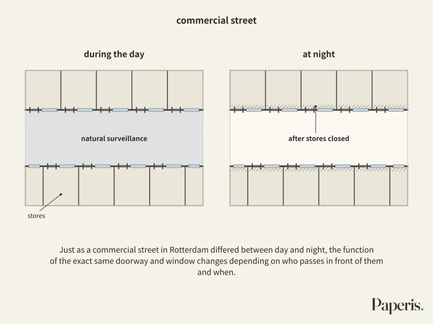
That does not mean design elements have nothing to do with crime. A study published in an open criminology repository used a statistical model to analyze 459 residential burglaries to see which street segments offenders chose (DOI: 10.21428/cb6ab371.17cf822e). It is not confirmed in the sources for this article whether this version underwent peer review, and the studied location does not appear in the abstract. Estimating how many footsteps from local residents and outsiders would pass through based on street connectivity structures, streets estimated to have more footsteps from outsiders had a higher risk of burglary, while streets estimated to have more footsteps from locals had a lower risk (DOI: 10.21428/cb6ab371.17cf822e). The authors consider these results to align with Newman's concept of defensible space (DOI: 10.21428/cb6ab371.17cf822e). In a study comparing spatial structure by counting police-reported sexual assaults street by street across four neighborhoods in Rotterdam, Netherlands, streets where entrances were clearly visible to one another were safer, and streets with mixed uses were safer than streets with only a single use (DOI: 10.3390/su12187609). Commercial streets were safe during the day but had many reports at night, which the authors attribute to the loss of natural surveillance from ground-floor windows after stores closed (DOI: 10.3390/su12187609). Both studies looked at associations where the location of crime moved together with street characteristics; they were not experiments testing whether changing streets reduced crime.
A study in Cardiff, Wales, asked urban planners, police officers, and convicted burglars to look at various housing designs and point out spots prone to crime; the authors themselves stated that the survey was tied to local culture, and summarized that defensible space theory remains largely untested and past results have been mixed (DOI: 10.1080/13563470220132218). In another interview study where various British housing types were shown via slides, people drew a hierarchy of vulnerability to crime across housing types, and the outward appearance of even identical designs heavily influenced that judgment (DOI: 10.1108/eum0000000005784). The authors view this hierarchy as supporting Newman's theory (DOI: 10.1108/eum0000000005784). This is an exploratory interview study, and what was measured was how people perceive crime. Taken together, the simple equation that "tall buildings breed crime" was not supported by the 1977 Sheffield city survey data, and within the evidence of this article, that single city is the only one with crime data directly comparing height and crime. Small design elements such as lines of sight and access points moved alongside crime locations in data from other cities and streets.
Crime Prevention Through Environmental Design, Gathered Together
The idea of defensible space later became the foundation of design practice. Crime prevention through environmental design is an approach that aims to reduce the opportunities for crime to occur by changing the physical environment of buildings and streets. It is commonly called CPTED by taking the English initials. A critical review notes that both CPTED, developed in the United States and Canada, and "Secured by Design" in the UK drew upon defensible space as the basis of their theory (DOI: 10.1108/02637470110388235). The same review writes that design itself is not a cure-all, concludes that CPTED should be viewed as one crime prevention strategy among others that can play a part in reducing residential crime, and points to research on how various stakeholders view defensible space as the next path (DOI: 10.1108/02637470110388235).
Just how big that part is only becomes visible when scattered evaluation studies are gathered together. A meta-analysis is a method that gathers the results of multiple studies addressing the same question and recalculates them all at once. A 2026 meta-analysis that searched and gathered evaluation studies of environmental design interventions implemented in residential areas from three databases according to a set procedure included 31 papers, and among them grouped violent crime and property crime separately using 29 papers for which effect sizes could be calculated (DOI: 10.1007/s10610-026-09659-y). Property crime decreased on average, while violent crime varied greatly from study to study, showing no clear effect on average (DOI: 10.1007/s10610-026-09659-y). Looking by type of intervention, measures to harden doors and windows and access control consistently went hand in hand with a decrease in property crime (DOI: 10.1007/s10610-026-09659-y).
This result comes with a caveat. In all analyses, the variation in effects across studies was large, and the authors read this to mean that the effectiveness of interventions varies greatly depending on the context (DOI: 10.1007/s10610-026-09659-y). The authors' conclusion is that "certain environmental design intervention can reduce crime in residential areas, particularly property crime," and immediately following, they write that due to large differences between studies and differences in research methods, the results must be interpreted with caution, and the crime prevention effect appears to depend on the type of intervention and the context (DOI: 10.1007/s10610-026-09659-y). The authors add that future research should report results more consistently, use more robust study designs, and systematically examine context and implementation processes (DOI: 10.1007/s10610-026-09659-y).
In the same meta-analysis, demolition showed a much larger effect regardless of the type of crime, though this result comes with the caveat that the evidence is sparse (DOI: 10.1007/s10610-026-09659-y). Whether demolition changed life outcomes other than crime is another question. A working paper following children from families that had to move as public housing was demolished in Chicago reports that using the catalyst of demolition—which the families did not choose themselves—children's academic achievement neither improved nor worsened compared to peers (DOI: 10.3386/w9652). Pointing out that most households leaving through demolition moved to neighborhoods and schools very similar to the ones they left, the author argues that getting rid of high-rise public housing does not necessarily bring the gains recorded in other mobility experiments (DOI: 10.3386/w9652). It is a working paper prior to peer review, and what was measured is academics instead of crime. The act of tearing down buildings and the improvement of the circumstances of the people who lived inside them may not be the same thing.
Why the Same Design Yields Different Results
One reason the effects vary across studies is that design elements clash with one another. A conference paper systematically reviewing the literature reports that while many papers show that territoriality, natural surveillance, and access control are effective in preventing residential burglaries, they frequently undermine each other's effects, noting that some physical elements of access control and territoriality collide with natural surveillance or diminish its efficacy (DOI: 10.1088/1757-899x/636/1/012017). The same review finds, conversely, that the social aspect of territoriality—namely, neighbors jointly caring for the land—magnifies the effect of natural surveillance (DOI: 10.1088/1757-899x/636/1/012017). Concluding that these elements must be considered together rather than separately, the authors write that more evidence is needed comparing the impact of each element on burglary at a single location (DOI: 10.1088/1757-899x/636/1/012017).
Another strand of evidence points toward interpersonal relationships. A study surveying 1,420 people who moved to 74 new neighborhoods in Perth, Australia, before their move and 12 months after the move has been published as a conference abstract (DOI: 10.1136/injuryprev-2012-040580a.28). After the move, people's perceived safety increased, which went hand in hand with a decrease in vacant land, perceived improvements in street lighting and traffic safety, and perceived reductions in graffiti and vandalism (DOI: 10.1136/injuryprev-2012-040580a.28). The factor most strongly associated with increased perceived safety was heightened social cohesion, whereas changes in the physical environment itself had little to do with safety (DOI: 10.1136/injuryprev-2012-040580a.28). However, the authors note that these people generally relocated to urban fringes where infrastructure was still being established, and that further follow-up is needed to determine whether this relationship stems from the novelty of having just moved into a new neighborhood (DOI: 10.1136/injuryprev-2012-040580a.28). This study measured perceived safety, not actual crime.
Offenders are not uniform either. In the aforementioned study of 459 burglaries, the authors report that offenders differed in their "preferences" for choosing streets, leaving the explanation of this phenomenon as a task for future research (DOI: 10.21428/cb6ab371.17cf822e). A theoretical paper tracing the 35-year journey of defensible space theory reports that "milieu" is the most ambiguous of Newman's core concepts, and explains that this concept relies on spatial layout, ease of access, land use, and the everyday activities of that place (DOI: 10.1177/1477370808098103). Just as a commercial street in Rotterdam differed between day and night, the function of the exact same doorway and window changes depending on who passes in front of them and when. Literature reviews, theoretical papers, and meta-analyses consistently point in the direction that even with the same design, its effect can vary depending on surrounding usage and people's relationships—in other words, the context. Research directly measuring this direction in a single location is absent from the evidence in this article.
Still Debated
First, what is debated is what crime numbers are actually counting. The earlier Cardiff study points out that CPTED often relies on police-recorded crime statistics, and that this data consistently misrepresents actual crime and is unsuited for comparing very small units within a neighborhood (DOI: 10.1080/13563470220132218). A doctoral dissertation critically reviewing crime geography suggests that crime maps drawn from police statistics can reflect law enforcement's selective choices just as much as criminal behavior, and that enforcement practices can partly manufacture a neighborhood's status as a "problem area" (DOI: 10.14288/1.0095865). Even if a housing complex's reputation for danger is solidified by numbers, those numbers may be mixed with the choices of those enforcing the law.
Second is the effect of demolition and major structural changes. In a meta-analysis, demolition showed much larger effects regardless of crime type, but it stands on thin evidence (DOI: 10.1007/s10610-026-09659-y). Separately, the effects of environmental design interventions as a whole on violent crime varied widely from study to study (DOI: 10.1007/s10610-026-09659-y). Third is the theoretical mechanism. By what pathway defensible space leads to crime remains partly obscure even after 35 years of research, and that theoretical paper proposes rebuilding defensible space within a broader crime prevention theory that deals with the situations and opportunities where crime occurs (DOI: 10.1177/1477370808098103). The 1977 Sheffield study recommended more rigorous definitions (DOI: 10.1080/00420987720080321), and the 2009 theoretical paper considers that obscure parts remained in the theory even 35 years later (DOI: 10.1177/1477370808098103).
There are also areas where the evidence leans in one direction. In the evidence examined by this article, the simple equation "tall buildings equal crime" was not supported by crime data from the single city of Sheffield in 1977, and in a survey of older adults measuring fear, high-rise residents' fear was lower than predicted. In Portland, once other variables were adjusted, no clear effect of public housing was seen. Conversely, the claim that "design is irrelevant" also fails in the face of a meta-analysis showing that environmental design interventions, such as measures to fortify doors and windows and block access, reduced property crime on average. The authors add that differences between studies are large, so they should be read with caution (DOI: 10.1007/s10610-026-09659-y). Where opinions diverge is on the magnitude and conditions in between.
So What Did We Learn
We return to that scene from 1972. Within the frame are three collapsing buildings (DOI: 10.1080/10570319909374643). Bristol widens that frame, bringing in the postwar economic and political conditions of St. Louis that built and managed this complex. He calls the narrative that pins the blame on the designer a myth, arguing that it turns our gaze away from institutional and structural causes (DOI: 10.1080/10464883.1991.11102687). Heathcott argues that earlier, in 1934, the first achievements of the city's housing reformers paired modern design with plans that segregated residents, and that prototypes formed up until around World War II shaped postwar projects including Pruitt-Igoe (DOI: 10.1525/jsah.2011.70.1.82). A rhetorical analysis suggests that the issues of race and poverty were obscured in the shadow of this same myth (DOI: 10.1080/10570319909374643). Of these, only Bristol's piece directly addresses the cause of the decline, and none of the three are documents that count and compare crimes. The conclusion they jointly support goes up to "A single design cannot explain the decline."
Looking outside the frame does not erase design elements. However, that evidence did not come from this complex. In studies measuring crime in other cities and on other streets, elements like windows, entrances, and paths moved together with the locations of crime. A study on burglary published in an open repository found that the risk of burglary was lower on paths estimated to have more foot traffic from neighborhood residents (DOI: 10.21428/cb6ab371.17cf822e), in Rotterdam paths where entrances were visible to one another were safer (DOI: 10.3390/su12187609), and a meta-analysis gathering residential intervention studies showed that measures strengthening doors and windows and restricting access went hand in hand with a reduction in property crime (DOI: 10.1007/s10610-026-09659-y). Studies measuring crime at Pruitt-Igoe are absent from this article's evidence.
The word "design" has pointed to two things in this article. One is the shape of the building, such as height and style, and the other is small elements like doors, windows, entrances, and paths, as well as interventions that alter them. Within the evidence of this article, building height was directly compared to crime in only one city, Sheffield, in 1977, and it did not yield results showing that high-rises were disadvantageous (DOI: 10.1080/00420987720080321). Small elements and interventions moved alongside crime, but their magnitude varied greatly across studies. Interventions that alter design elements such as doors, windows, and entrances are one of several conditions that move alongside the locations of crime, and their effect varied greatly across studies, appearing to depend on the type and context of the intervention (DOI: 10.1007/s10610-026-09659-y). The institutions and structures summoned by Bristol enter alongside to explain the decline of a single complex. Methods for bringing the words of those who lived there back into the next building were covered in Paths and Use — A Newcomer's Steps, an Occupant's Word. The demolition scene of Pruitt-Igoe took on a single narrative, and subsequent studies re-read the institutions outside the frame while measuring design elements in other cities and streets.
Source Papers
- "Architectural Effects of Urban Renewal in St. Louis: An Examination of High-Rise Housing Development in St. Louis" (2017) — DOI: 10.7936/xfxh-fv09 — Master's thesis. The history of low-rent high-rise public housing in St. Louis before 1965, with Pruitt-Igoe being the largest and best-known complex among them.
- "The Pruitt-Igoe Myth" (1991) — DOI: 10.1080/10464883.1991.11102687 — Traces the history of how demolition became a symbol of modern architecture's failure, concluding that myths blaming designers divert attention from institutional and structural causes.
- "Refraining the ruins: Pruitt‐Igoe, structural racism, and African American rhetoric as a space for cultural critique" (1999) — DOI: 10.1080/10570319909374643 — The demolition of the first three blocks in 1972. A rhetorical analysis viewing the "design flaw" myth as masking issues of race and poverty.
- ""In the Nature of a Clinic": The Design of Early Public Housing in St. Louis" (2011) — DOI: 10.1525/jsah.2011.70.1.82 — Historical research showing that reformers' first complex in 1934 featured modern design paired with social planning that segregated residents, serving as a model for the 1937 Housing Act projects, and that archetypes built up to World War II shaped postwar projects including Pruitt-Igoe.
- "Urban Typology is Not Destiny: The High-Modernist Tower and Slab as a Global Outlier in Singapore" (2026) — DOI: 10.31235/osf.io/xws3b_v2 — Unrefereed preprint. Views the decline of high-rise slab apartments as a result of welfare cuts, fiscal depletion, and neglect, explaining Singapore's success through political and economic conditions.
- "IN DEFENSE OF SPACE: HOUSING AND CRIME PREVENTION THROUGH ENVIRONMENTAL DESIGN" (Included in 2020) — DOI: 10.2307/j.ctvzgb8dq.8 — Bill Hillier's critical essay. Reports the enthusiastic reception of Defensible Space and critiques the concept of territoriality.
- "Defensible Space: A Theoretical and Empirical Appraisal" (1977) — DOI: 10.1080/00420987720080321 — Tested with Sheffield survey data, finding no disadvantage for high rises, and recommending a more rigorous definition as the concept is too broad.
- "The Defensible Space Model of Fear and Elderly Public Housing Residents" (1988) — DOI: 10.1177/0013916588201003 — Survey of 945 elderly residents, finding counter to predictions that high-rise residents have lower fear.
- "Does walkability undermine neighbourhood safety?" (2016) — DOI: 10.1080/13574809.2016.1247644 — Three years of crime data from Portland, showing walkability is positively associated with burglary, with no significant effect for public housing.
- "ROLE OF THE STREET NETWORK IN BURGLARS' SPATIAL DECISION-MAKING" (2017) — DOI: 10.21428/cb6ab371.17cf822e — Criminology open repository edition (peer-review status unverified). Choice model of 459 burglaries, showing higher risk when street network structure estimates more outsider foot traffic and lower risk when neighborhood foot traffic is higher, with preferences varying by criminal.
- "Sexual Violence in the City: Space, Gender, and the Occurrence of Sexual Violence in Rotterdam" (2020) — DOI: 10.3390/su12187609 — The relationship between street-level sexual assault reports and spatial structure across four Rotterdam neighborhoods, showing streets with mutually visible entrances are safer, and commercial streets at night are riskier.
- "Criminogenic Associations and Characteristic British Housing Designs" (2002) — DOI: 10.1080/13563470220132218 — Study of perceptions among Cardiff planners, police, and convicted burglars, finding defensible space theory is largely untested with mixed results, alongside limitations of recorded crime statistics.
- "Crime and the design of residential property – exploring the perceptions of planning professionals, burglars and other users: Part 2" (2001) — DOI: 10.1108/eum0000000005784 — Slide interview exploratory study on the impact of housing form hierarchies and appearances.
- "Crime and the design of residential property – exploring the theoretical background ‐ Part 1" (2001) — DOI: 10.1108/02637470110388235 — Critical review noting defensible space is the foundation of CPTED and Secured by Design, and design alone is not a panacea.
- "Crime Prevention in Residential Areas A Systematic Review and Meta-Analysis of Environmental Design Approaches" (2026) — DOI: 10.1007/s10610-026-09659-y — 31 papers (29 papers calculated), showing reduced property crime, mixed results for violent crime, high heterogeneity, scant evidence for demolition effects, and calling for cautious interpretation.
- "Public Housing, Housing Vouchers and Student Achievement: Evidence from Public Housing Demolitions in Chicago" (2003) — DOI: 10.3386/w9652 — Working paper. No change in academic achievement for children in families that moved due to demolition, as they relocated to similar neighborhoods.
- "Creating Secured Residential Places: Conflicting Design Elements of Natural Surveillance, Access Control and Territoriality" (2019) — DOI: 10.1088/1757-899x/636/1/012017 — Conference paper, literature review. Physical elements of access control and territoriality conflict with natural surveillance, requiring more evidence.
- "PLANNING SAFER SUBURBS? THE INFLUENCE OF CHANGE IN THE BUILT ENVIRONMENT ON RESDIENTS' PERCEIVED SAFETY FROM CRIME" (2012) — DOI: 10.1136/injuryprev-2012-040580a.28 — Conference abstract. Survey of 1,420 Perth residents before and after moving, showing social cohesion increases perceived safety the most, with physical changes having little impact.
- "The Future of Newman's Defensible Space Theory: Linking Defensible Space and the Routine Activities of Place" (2009) — DOI: 10.1177/1477370808098103 — Theoretical paper. "Image" is the most ambiguous concept, reconceptualized by linking it to the routine activities of a place.
- "Geography, crime and social control" (Doctoral dissertation) — DOI: 10.14288/1.0095865 — Critical review addressing the potential distortion of police crime mapping and "ecological stigmatization."
Sources (20)
- Architectural Effects of Urban Renewal in St. Louis: An Examination of High-Rise Housing Development in St. LouisDOI 10.7936/xfxh-fv09
- The Pruitt-Igoe MythDOI 10.1080/10464883.1991.11102687
- Refraining the ruins: Pruitt‐Igoe, structural racism, and African American rhetoric as a space for cultural critiqueDOI 10.1080/10570319909374643
- In the Nature of a Clinic\DOI 10.1525/jsah.2011.70.1.82
- Urban Typology is Not Destiny: The High-Modernist Tower and Slab as a Global Outlier in SingaporeDOI 10.31235/osf.io/xws3b_v2
- IN DEFENSE OF SPACE: HOUSING AND CRIME PREVENTION THROUGH ENVIRONMENTAL DESIGNDOI 10.2307/j.ctvzgb8dq.8
- Defensible Space: A Theoretical and Empirical AppraisalDOI 10.1080/00420987720080321
- The Defensible Space Model of Fear and Elderly Public Housing ResidentsDOI 10.1177/0013916588201003
- Does walkability undermine neighbourhood safety?DOI 10.1080/13574809.2016.1247644
- ROLE OF THE STREET NETWORK IN BURGLARS' SPATIAL DECISION-MAKINGDOI 10.21428/cb6ab371.17cf822e
- Sexual Violence in the City: Space, Gender, and the Occurrence of Sexual Violence in RotterdamDOI 10.3390/su12187609
- Criminogenic Associations and Characteristic British Housing DesignsDOI 10.1080/13563470220132218
- Crime and the design of residential property – exploring the perceptions of planning professionals, burglars and other users: Part 2DOI 10.1108/eum0000000005784
- Crime and the design of residential property – exploring the theoretical background ‐ Part 1DOI 10.1108/02637470110388235
- Crime Prevention in Residential Areas A Systematic Review and Meta-Analysis of Environmental Design ApproachesDOI 10.1007/s10610-026-09659-y
- Public Housing, Housing Vouchers and Student Achievement: Evidence from Public Housing Demolitions in ChicagoDOI 10.3386/w9652
- Creating Secured Residential Places: Conflicting Design Elements of Natural Surveillance, Access Control and TerritorialityDOI 10.1088/1757-899x/636/1/012017
- PLANNING SAFER SUBURBS? THE INFLUENCE OF CHANGE IN THE BUILT ENVIRONMENT ON RESDIENTS' PERCEIVED SAFETY FROM CRIMEDOI 10.1136/injuryprev-2012-040580a.28
- The Future of Newman's Defensible Space Theory: Linking Defensible Space and the Routine Activities of PlaceDOI 10.1177/1477370808098103
- Geography, crime and social controlDOI 10.14288/1.0095865